Geog Unit 1

?

Trends in the number of reported hazards

A higher percentage of hazards are becoming disasters as they affect increasing numbers of people

The number of reported disasters has risen sharply since the 1960s this could be due to the media and better communication and better technology. However it could also be due to increased population and an increased amount of people living in poverty especially in the continent of Africa.

1 of 41

Hydro meteorological disasters

Hydro meteorological disasters- have increased rapidly since the 1960s. Many scientists believe this could be due to climate change however the situation is complex. Floods and storms account for 7 out of 10 of all disasters in the last 40 years.

2 of 41

Geophysical hazards

Geophysical hazards- geophysical hazards such as earthquakes have increased very slightly since the 1970s. However this could be due to not only increased reporting of disasters but also the rising number of people living in hazard risk areas. Currently Indonesia is a ‘hotspot’ for tectonic activity as the Indian plate is being subducted beneath the Burma plate at a destructive plate boundary.

3 of 41

example

Himalayas

Plate boundary between Eurasian and Indian plate (destructive continental - continental)

Hazards: some of the largest earthquakes in low lying land

Opportunity: It created the Himalayas ( good for farming and reduces impacts of the settlements)

Threat : low lying foothills or coastal plains carry a massive threat for life of people living there 

4 of 41

Biological hazards

Biological hazards- have shown an upward trend from a low base, often numerically exceeding geophysical hazards. This may be linked to climate change as increased temperatures lead to more pests and diseases such as malaria.

5 of 41

Plate boundaries

Plates moving towards eachother (continental - oceanic) oceanic subducted as its more dense. This is then heated and melted forming magma due to the friction and contact with upper mantle. The magma rises forming volcanoes. Japan trench ( eurasian and pacific plate). Deep ocean trenches mark where the plate has subducted. fold montains are also created. The friction between the colliding plates causes immediate and deep earthquakes called the benioff zone

(oceanic - oceanic) same process occurs with the more dense subducting however they can get stuck which causes the plates to jerk because of the build up of pressure therefore forming an earthquake. Volcanic islands of indonesia. forms Island Arcs 

(continental - continental) neither is subducted so no volcanoes but the build up of pressure causes earthquakes. Kashmir 2005

6 of 41

Global distribution

Causes:

They are caused by movement in tectonic plates which involves gas. Earthquakes are caused by the plate friction when moving. These can then go on and cause a tsunami and volcanic activity is caused by a constructive plate boundary when gaps open up (these are both caused along plate boundaries).

The global distribution:

Volcanoes - narrow belts along plate margins, normally occuring in the ring of fire around the pacific ocean. An exception of this is the one right in the centre of the pacific ocean as it does not lie on a plate boundary.

Earthquakes - They are also found along narrow belts along plate margins but are more widespread. The marjority is around areas like Chile. An exception are the earthquakes on inland Australia as they dont lie on a plate boundary.

7 of 41

Intra plate processes

Causes:

They are caused by movement in tectonic plates which involves gas. Earthquakes are caused by the plate friction when moving. These can then go on and cause a tsunami and volcanic activity is caused by a constructive plate boundary when gaps open up (these are both caused along plate boundaries).

The global distribution:

Volcanoes - narrow belts along plate margins, normally occuring in the ring of fire around the pacific ocean. An exception of this is the one right in the centre of the pacific ocean as it does not lie on a plate boundary.

Earthquakes - They are also found along narrow belts along plate margins but are more widespread. The marjority is around areas like Chile. An exception are the earthquakes on inland Australia as they dont lie on a plate boundary.

8 of 41

Plate boundaries

The distribution of plate boundaries resulting from divergent, convergent and conservative plate movements (oceanic, continental and combined situations)

Earths crust is made up of tectonic plates which sit on top of the mantle. 

Two types:

Continental - Thicker, less dense (above sea level)

Oceanic - Thinner, more dense (below sea level)

Plate movement down to the convection current - caused by temperature differences in the mantle.

Three types of plate boundary - conservative (transform margins) , constructive (divergent) and destructive (convergent).

The area adjacent to the boundaries are called plate margins- areas around the plate boundary which may be affected from the movement 

9 of 41

Plate boundaries Extended

Conservative - EARTHQUAKES 

Plates moving past eachother. This is where the plates lock together and pressure builds up - jerk past eachother forming fault lines releasing energy as an earthquake. Although it doesnt cause much damage it is tectonically very active. San Andreas Fault California

Constructive -  EARTHQUAKES AND VOLCANOES

Plates moving apart (mantle is under pressure so when they move apart the pressure is released which causes the mantle to melt forming magma. The magma then rises because it is less dense forming a volcaono. However this movement is not uniform which causes pressure to build up and when it becomes too much the plate cracks forming a fault line leads to an earthquake) Mid ocean ridges - regular breaks (transform faults) cut across the ridges at different speeds creating shallow focus earthquakes mainly minor. They also create submarine volcanoes along the mid ocean ridges to create new islands - Iceland on mid Atlantic ridge. 

Rift valleys - plates move apart on coninents the crust streches - breaks into parralell faults - the land between the collapses forming rift valleys 

Volcanoes away from plate boundaries - volcanic hotspots

10 of 41

impacting magnitude

Physical processes impact on the magnitude and type of volcanic eruption, and earthquake magnitude and focal depth (Benioff zone)

see 1.1b for the plate boundaries 

examples:

  • constructive- Mid-atlantic ridge 
  • destructive (continental - continental) Himalayas
  • destructive (continental - oceanic) Nazca and south America
  • conservative - San Andreas Fault 

Benioff zone- The area where friction is created between colliding tectonic plates resulting in immediate and deep earthquakes. The deeper the earthquake the less damaging it is because it has more time for the energy to dissipitate therefore less energy released close to the surface

11 of 41

Key words 1

Subduction

As new crust is being created in one place it is being destroyed in another - by subduction. As the two plates move into eachother the denser one slides underneath into the mantle where it melts (subduction zone)

Seafloor spreading

In the middle of many oceans there are ocean ridges, or mountain ranges. they are formed when hot magma is forced up into the athenosphere and it hardens forming new crust. The new crust  then pushes the plates apart in a process called sea floor spreading. This has been confimed by paleomagnetism. 

12 of 41

Paleomagnetism

Paleomagnestism - The study of past changes in the earths magnetic field

every 400 000 years or so the magnetic fields change direction - north and south swap. When lava cools the mineral inside line up with earths magnetic direction at this time. Scientists studying this found the same pattern either side of the mid- ocean ridges ( this could only be done if the rock was being formed at the same time on both sides) 

13 of 41

main global hazard trends

1.       The number of reported disasters has increased rapidly since the 1960s

2.       The number of fatalities due to natural disasters is falling

3.       The number of people affected by disasters in rising

4.       The amount of economic loss due to global disasters is increasing

14 of 41

Plate tectonic theories

Plate tectonic theories:

lithosphere is broken into tectonic plates which move over the athenosphere. This can cause earthquakes, volcanoes etc. The different processes:

Mantle Convection -now less accepted 

describes it as when the heat is produced by the decay of radio active elements in the core heats the lower mantle which creates convection currents. (moving in circles in athenosphere causing the plates to move)

Slab Pull - increasingly popular (major driving force)

newly formed oceanic crust at mid-ocean ridges becomes denser and thicker as it cools which causes it to sink into the mantle pulling the rest of the plate further down aswell.

15 of 41

Harry hess

The theory of plate tectonics and its key elements (the earth’s internal structure, mantle convection, palaeomagnetism and sea floor spreading, subduction and slab pull).

Harry Hess - seafloor spreading

explanation for continental drift 

  • found a mountain range on the flat sea floor - mid-atlantic ridge
  • subduction and seafloor spreading rel.
  • palaeomagnestism

Wilson Cycle

  • slab pull rel.
  • ocean basin opened up then closed again when plates contracted = continental collison
16 of 41

Earth structure

6500km to the centre of the core and the heat is over 6000 C, this means they map it using evidence from seismic waves.

Three layers:

Core - Inner (centre and is the hottest part, it is solid and mostly consists of iron) Outer (semi-molten and mostly consists of liquid iron and nickel temp 4500 C - 6000 C)

Mantle - Surrounds core (widest layer) upper part solid but below its semi molten forming the Athenosphere

Crust - outer shell Oceanic (6-10km thick) Continental ( 45-50km thick older less dense) 

between crust and upper mantle is the lithosphere (solid layer from which the tectonic plates are made)

17 of 41

Waves

seismic waves are the way earthquakes energy is released which radiate out from the focus. There are three types Primary, Scondary and Love waves. These can be measured using a seisometer which detects and mesaures ground movement. There are also two types of waves body and surface waves

Body waves

travel through inner layers of earth and arrive at the crust before the surface waves are emitted. They also have a very high frequency compared to surface waves.

Surface waves

They come after body waves and move along the surface like ripples they have a lower frequency but are responsible for damage.

The deeper the focus of the earthquake the more the damage and strength decrease due to the loss of energy.

18 of 41

Wegners theory

Wegner - continental drift theory 

' continents were once all joined in a super continent - Pangea and now have broken apart

Evidence:

  • continents fit together ( east south Ameria and west Africa)
  • fossil correlation ( mesosaurus (shallow fresh water) fossils found in east Brazil and west Africa so they must have been once joined as there is now salt water between)
  • mountain range of same age and rock in east Brazil and west Africa
  • glaciers leaving straitions  found in south America and Africa - werent always in tropical climate
  • matching rock types
  • in Antarctica coal was found - formed by the compression of tropical plants suggesting it wasnt always in a tropical climate
19 of 41

Tropical storms

They develop when sea temps are over 26.5 degrees -- warm moist air rises and condenses - releasing energy which increases wind speed. As they move over land they lose strength as their warm air supply cut off .They spin because of the coriolis effect (the force that deflects the path of winds due to earths rotation. This is also why they move away from the equator. They move westwards due to east-west winds in the tropics.

Image result for tropical cyclone distribution cgp (http://1.bp.blogspot.com/-zjE2b1KkfeM/VD9fnyj8XJI/AAAAAAAAAD0/Z86CBaunegw/s1600/tropical-cyclones.gif)

20 of 41

VEI scale

The explosive scale is the VEI scale which is used to show the size of the volcaon

Image result for vei scale

21 of 41

waves extended 2

Image result for p s l waves (http://image.slidesharecdn.com/7thgrade-ch-2sec-2earthquakesseismicwaves-100913154901-phpapp01/95/6th-grade-ch-2-sec-2-earthquakes-seismic-waves-9-728.jpg?cb=1411468183)

22 of 41

Magnitude

Magnitude and Intensity are used to measure earthquakes 

Magnitude - amount of energy released from epicentre

Moment Magnitude Scale (MMS) is preffered as it is accurate. It measures the size of the earthquake using

  • the size of the seismic wave
  • amount of rock movement
  • area of the fault surface broken by the earthquake
  • resistance of the affected rock

The scale goes from 1- infinity but highest reached is 9.5 (Chile 1960). Logarithmic (10x magnitude than number before)

Intensity - the earthquakes effect on people, structures and the natural environment. This is measured using the Modified Mecalli Intensity Scale from I (hardly noticed) to XII 

23 of 41

Volcano Primary hazards

Lava flows - streams of lava that have hit eaths surface - very hot and take years to cool completely, however generlly not a threat because they mainly move slowly but they destroy everything in their path

Pyroclastic flows - mixture of hot rock, ash, lava and gasses which are ejected from a volcano. They move very quickly and destroy everything they touch. More dangerous and very hot

Ash Falls (Tephra) - Tephra are pieces of rock and ash that blast into the air, largest land nearest volcano - cause deaths. Ash falls cause roofs to collapse and it covers everything.

Gas erruptions - Magma contains dissolved gasses that get released into the atmosphere and can travel thousands of kilometers. contains water vapor (80%) CO2, SO4

24 of 41

Vulnerability- Less Developed 2

Economic and Social Conditions

  • Their level of wealth impacts ability to protect themselves and the community 
  • Access to eduction - more aware of the event
  • Poor - Quality housing - cant withstand the pressure
  • Health care - if its poor you are more likely to suffer and unable to cope 
  • lack of income - unable to buy resources 

Governments are key players as they can construct good infrastructure, have good financial management and be prepared for the worst

25 of 41

Earthquake Hazards

Aftershocks - smaller earthquakes

happen as a result of earth settling down

they can cause aditional damage ie 2011 Christchurch 6.3 magnitude one instead of the real earthquake in 2010

Predicting 

no way of prediting but have warnings 

they know that they happen along plate boundaries and the areas which have the big ones so they are able to forecast them but not exactly when they will happen. 

the research today focuses on getting the warning signs - precursors that suggest a major earthquake will happen. This can be done using foreshocks but they havent proved as a reliable source yet. 

26 of 41

Volcano Secondary hazards

Lahars - masses of rock, mud and water that travel quickly down sides of volcanoes. it varies in size and speed - can be too fast to outrun. Formed when an eruption meets snow and ice or it can be heavy rainfall during/after an eruption erodes lose rock causing a surge downhill.

Jokulhlaup - melting of the snow and ice in a glacier causing heavy flooding (jokulhlaup) can be very dangerous suddenly release large amounts of water, rock,gravel and ice - catching people unaware.

27 of 41

Tsunami Formation

28 of 41

Tsunami Prediction

predicting:

unable to predict but you can use early warning systems 

They use a system called DART. This system uses seabed sensors and surface bouys to measure changes and pressure. When the tsunami waves are picked up the information goes via satalite to warning stations where they estimate the size and direction before informing the areas at risk.

29 of 41

Vulnerability- Less Developed

less developed = more vunerable 

Governance and political conditions

  • enforcement of building regulations determining the quality and safety of them 
  • quality of existing infrastructure affects recovery speed
  • preparedness plans influence how quickly and effectively the country can respond
  • efficiency of emergency services 
  • quality of communication systems - informing people in advance
  • practiced hazards responses and public education 
  • level of government corruption

Physical and environmental conditions 

  • high population density - low quality housing
  • rapid urbanisation - quickly construct houses of low quality 
  • accesibility of an area 
30 of 41

PAR model

Based on the idea that two opposing forces cause a disaster - vunerability and the hazard itself

Image result for pressure and release model geography (http://maxa.maf.govt.nz/mafnet/rural-nz/adverse-events/snow/farm-response-to-2006-canterbury-snow/page-4.jpg)

31 of 41

Hazard Profiles

Hazard Profiles - a diagram that shows the main characteristics of different types of tectonic hazards to allow easy comparison.

Ok to do for same type of hazard but not reliable when its done for two different hazards

More complex ones have more detail

Image result for hazard profile

32 of 41

Mercalli scale

Mercalli scale

it is used to measure earthquakes on the scale I - XII in a relative scale

Measures the impacts of the disaster

Image result for mercalli scale modifies (http://earthquakenepal2015.weebly.com/uploads/2/2/4/1/22417332/534913861.png)

33 of 41

Moment Magnitude Scale (MMS)

Moment Magnitude Scale (MMS)

Its used to measure earthquakes from 0-9 in the terms of energy release.

It is based on the seismic moment of the earthquake

Image result for mms scale (http://www.marshallcoema.org/mitplan/files/chart5-1.png)

34 of 41

waves extended

Types of body waves

P waves: 

  • arrive at detector first, longitudinal waves and cause little damage

S waves:

  • arrives at detector second, transverse waves and cause lots of damage

L waves:

  • fastest wave, moves side to side entirely horizontal and causes lots of damage 
35 of 41

Dreggs model

comparing Dreggs Model, Risk Equation and the PAR model 

Image result for dregg disaster model (http://image.slidesharecdn.com/naturalhazardsanddisasters-140910050542-phpapp02/95/natural-hazards-and-disasters-9-638.jpg?cb=1410325615)

36 of 41

Eathquake Secondary hazards

Earthquake waves (P, S and L waves) cause crustal fracturing, ground shaking and secondary hazards (liquefaction and landslides).

The impacts depends on a range of factors both physical (magnitude, depth etc. ) and human (development, population etc.). These can be classified as primary or secondary 

Primary Effects: - direct result

  • Crustal fracturing - the energy from an earthquake causes the crust to crack which leaves gaps
  • Ground Shaking - causes the infrastructure to collapse can also kiil/injure peole as a result

Secondary Effects: 

  • liquefaction - surface rocks lose strengh and become more liquid, loses the ability to support builidings and roads can tilt/sink making resuce efforts harder and can disrupt the power and gas lines
  • landslide - ground shaking causes stress on the slopes so they fail and collapse - account for massive proportion of the damage and injuries
  • Tsunami - underwater earthquakes cause these - major problems for coastal areas
37 of 41

Reasons that can magnify effects of a hazard

 Inequality of access to education, housing, healthcare and income opportunities can influence vulnerability and resilience.

 Governance (P: local and national government) and geographical factors (population density, isolation and accessibility, degree of urbanisation) influence vulnerability and a community’s resilience.

 Contrasting hazard events in developed, emerging and developing countries to show the interaction of physical factors and the significance of context in influencing the scale of disaster.

38 of 41

Definitions

Definition of a natural hazard and a disaster, the importance of vulnerability and a community’s threshold for resilience, the hazard risk equation

Natural Hazard - A naturally occuring process or event that has the potential to affect people

Natural disaster - a major natural hazard that causes significant social, environmental and economic damage

Vunerability - the ability to anticipate, cope with, resist and recover from a natural hazard
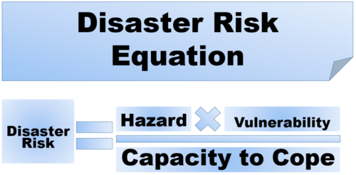
disaster equationImage result for disaster risk equation

Disaster resiliance - ability of individuals, communities, organisations and states to adapt and recover from hazard, shocks or stresses without comprimising long-term prospects for development

39 of 41

Volcanic Explosivity Index (VEI)

Volcanic Explosivity Index (VEI) 

Used to measure volcanic erruptions and an a scale from 0-8

calculated fom the volume of products,height of eruption and qualitive observations

Overall 

MMS, VEI and richter are logarithmic (up an index increases power by 10)Image result for vei scale

40 of 41

Tsunami

Most tsunamis are caused by large underwater eathquakes along the subduction zone. The energy that is released during an earthquake causes the sea floor to lift displacing the water column above. This water then causes a tsunami. 

The tsunami waves move quickly up to 805km per hour. When the waves crest reaches the shore it produces a vacuum effect - sucks back showing lots of the sea floor. This water then returns rapidly in the form of a tsunami.

  • Impacts- they can travel inland for several miles destroying everything in its path, wash away the soil - undermining foundations of buildings, change the landscape completely 
41 of 41

Comments

No comments have yet been made

Similar Geography resources:

See all Geography resources »See all Natural hazards resources »