

Ecosystems: change and challenge
- Created by: EmmaC
- Created on: 20-04-16 09:05
How does a food chain work?
The flow of energy through plnts and animals and then back to the sol is called a food chain.
At each trophic level 90% of energy is lost by respiration, excretion and a general transfer of heat to the atomosphere.
At each higher trophic level, fewer organisms can be supported. The organisms at higher levels are also often more complex and need more lower-level organisms are needed to support them.
As a result of the loss of energy, the biomass reduces.
Food chain for temperate deciduous woodland?
Grass --> Worm --> Blackbird --> Hawk
Autotroph -->Herbivore-->Carnivore-->Larger carnivore
What is the role of the sun in an ecosystem?
Maining driving force:
- Drives the watercycle
- Heat for the environment for plants and abiotic environments
- Provides the energy for photosynthesis
Key words 1
Ecology - The study of spatial patterns of soil, vegetation and whole ecosystems and everything around us.
Ecosystem - A set of relationships between all living and non living factors in a particular area.
Environment - Describes the conditions in which organisms live (biotic and abiotic factors).
Biome - Ecosystems on a continental scale on a large area with biotic characteristics influenced by climate
Microhabitat - Within a specific location e.g. under a leaf
Habitat - within a specific localised environment and a related community: e.g. a freshwater pond
Zone - major unit within a biome e.g. layers in a TRF such as Rainforest canopy
Niche - the role and position a species has in its environment
Key words 2
Food chain -Transferral of energy through an ecosystems with each link in the chain feeding on and obtaining energy from the link that precedes it.
Autotroph - Plant that can produce its own food via photosynthesis
Herbivore/Primary consumer -Plants and animals that can obtain energy by eatting green plants
Carnivore/Secondary consumer - meat eater
Omnivore - Organisms that eats both plants and meat
Decomposer - Organisms that takes remains of dead plants and animals as well as their excreted waste, and converts them back to CO2 and nutrients.
Trophic level - An organisms position in the food chain
Food web - More complex than a food chain, but more common. Variety of different sources of food at each trophic level and most animals in the web have more than one source of food.
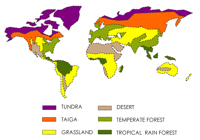
Where are the different biomes in the world?
What are the differences between biotic and abioti
Biotic factors are the 'living' enviornments such as insects, birds and disease
Abiotic factors are non living, physical and chemical components of the ecosystem such as climate, rock, relief and drainage
Explain the process of photosynthesis?
It is basically the process in plants that converts CO2 and H20 into Glucose plus oxygen.
The glucose allows the plants to grow and any surplus energy is stored.
Explain the energy cycle
Sunlight -> Photosynthesis -> Green Plants -> Consumers -> Secondary consumers -> Decomposers -> soil
From the soil it goes back into the green plants and so the cycle starts again.
Explain the nitrogen cycle
Explain the carbon cycle
Explain how nutrients are going to me recycled?
The soil componant contains minerals that come from weathered rock and humus that comes from decomposed plant and animal materials.
The biomass compartment contains all the living plant and animal material in the ecosystem. It takes in energy and carbon from the atmosphere and minerals from the soil.
The litter compartment is found on the top of the soil and is composed of dead and decaying plant and animal matter.
Nutrients are recyled through the compartment as flows.
These can be shown by Gershmel diagrams.
What does the Gershmel diagram for a tropical rain
What does the Gershmel diagram for a temperate dec
Explain the tropical gershmel diagram
Ideal for plant growth. Growth is so rapid that the biomass stored in the plants contains a huge proportion of the nutrients available.
Leaf litter is broken down quickly is hot, wet conditions, so litter store is also very small. So is the nutrient store as they are taken up quickly by plant growth.
The heavy rainfall can cause heavy leaching and carry minerals away from the area, making it infertile.
Explain the Temperate deciduous woodland gershmel
The forest is neither dense nor high as in rainforests so fewer nutrients are held in the vegetations.
However the autumn leaf fall decays fairly slowly in the lower temperatures, so there is a large store in the litter layer. The nutrients from this layer is then carried into the soil by decomposers such as worms, so the soil store is vital.
How do climate, vegetation, soil and animals inter
Changes between these factors can effect each other.
The most obvious way this can be seen is by seral progression.
Key words 3
Seral progression - The move from one sere to another
Sere - A stage in the development of the vegetation of an area over a period of time
Pioneer community - The first sere in an area (develops on a bare surface)
Climatic climax vegetation - The vegetation that is thought to evolve in a climate region if the seral progression is not interupted by human activity or other things such as tectonic activity
Dominant plant - The largest, most complex and tallest species present in a community
Prisere - The whole process from a pioneer community to the climx vegetation
Plagioclimax - Where human activity has permanently stopped and changed the natural vegetation
Sub-climax - a stage or community in an ecological succession immediately preceding a climax
Describe and explain lithosere succession
The bare rock surface is initially colonised by bacteria and algae which can survive where there are a few nutrients. Bare rock tends to be very dry and there is rapid surface run off.
The pioneers began to colonse, starting with lichens which can withstand the acute water shortage. They begin to break down the rock and assist water retention.
As water retention improves, mosses begin to grow. These also improve water retention and weathering to produce the beginnings of a thin soil in which more advanced plants can grow.
Ferns, herbs (Vetch) and flowering plnats appear. As these die back bacteria convert their remains into humus, which helps to recyle nutrients and further improve soil fertility.
Shrubs start to grow shading out grasses and herbs.
Pioneer species will become established such as trees, these are fast growing such as willow, birch and rowan.
Slower growing tree species begin to develop such as ash and oak. Initially they are in the shade of srubs so only appear in the later stage of succession. This becomes temperate decidous woodland.
Draw the succession of lithoseres
Describe and explain psammosere succession.
The movement of sand dune due to wind blowing inland, this can build up around an obstacle to accumulate and form a dune.
Embryo dune --> Sand starts to accumulate as plants which are mainly Marram grass are alble to survive a hostile enviornment with lots of salt, lots of wind and a high pH. The marram grass roots stabilises the dune letting it grow in size.
Fore dune --> Sand is building up on dunes. Embryo dunes join to form a bugger dune an it isnt as hostile so plants like sea rocket can grown, but marram is still dominant.
Yellow dune --> Sand id building up as plants die they form soil. These are yellow due to lack of soil. Plants cover 50-80% of the dune. Sea spurge starts to grow.
Grey dune --> Marram grass dies soil starts to form, layer of humus forms. More plants can therefore grow due to more nutrients. It therefore becomes more acidic and gorse can dominate.
Dune slack --> Depressions between dunes, below the water table, fill with water and reeds dominate.
Mature dune --> No longer recieves a fresh sand supply, and woodland forms.
Sketch and annotate a dune profile
Explain plagioclimax, sub-climax, arresting factor
If human impacts interupts the succession can produce a plagioclimax. Such as People preventing dune succession to keep beaches attractive to encourage tourism.
If the arresting factor (factor that orevents succession) is then removed a secondary succession develops.
Natural interuptions cih as impeded drainage can produce an interrupted succession and a subclimax community.
Where are TDW located?
Located --> East europe, East america, New Zealand, East coast of Australia, Southern tip of S.America and some parts of W.Europe.
40-60 degrees north and south of the equator.
Describe the climate of the UK?
- · Temperature ranges from 5 – 17 in Winter and Summer
- · 500-2,000mm of rain per year, varies seasonally
- · Low pressure systems
- · Westerly winds
Describe the vegetation of the UK
- · Broadleaved deciduous trees are the dominant species, oak are the tallest
- · Trees develop large crowns and broad but thin leaves
- · Shed their leaves in the winter, reduces transpiration when less water is available
- · Net primary production-1,200g dry organic matter per M² per year
- · Most woodlands show some stratification
- · Below the canopy is the shrub layer
- · Just above the forest floor is the herb layer
- · Epiphytes e.g. lichens and mosses grow on the trunks and branches of trees
- · A thick layer of leaf litter is readily broken down by soil microbes and animals
Describe the soil of the UK?
- · Brown Earth soil 1.5m deep
- · Leaf litter makes the soil more fertile in Autumn
- · Well mixed with decomposers so it becomes fertile quickly
- · Leaching occurs when there is snowmelt or intense rain, which is not uncommon
Draw the soil profile of TDW
Draw the profile of TDW
Features of the TDW biome?
Productivity -1,200g/m2
Dominant species - Oak and ash
Sub-dominant species - Holly, hazel and hawthron
Shrub species - bracken, fern and grass
Herb layer species - such as bluebells
Describe the brown earth soil in TDW
L horizon - Dead materal such as leaves and twigs on the surface called the litter layerBlack, amorphous mass of organic material called humus. Below the fermentation layer (bacteria decomposition)
A horizon - Humus is moved downwards by percolation of water into the soil. Brown due to the humus
B horizon - Precipitation exceeds evaporation there is a net downwards of movement of water through the soil. This leaches the minerals out of the top layers, depositing lower forming a reddish layer where iron oxides have been deposited.
C horizon - Layer of partly weathered parent material is reached, merging with weathered rock.
Exmoor heather moorland case study
Location: 693km2, 300-500m high plateau, 19,000ha of moorland, longer growing season than the rest of the UK, 700-900 red deer, 519m above sea level.
Uses of area: Majority is private ownership, rough grazing in summer by sheep, casaul tourism, 70 commercial game bird shoots
Management: Harsh planning regulations, removal of man made structures, burning and grazing supplemented, proposals to conserve woodlands, plans to restore uphill areas by remaining conifer plantations, the planning of biomass crops such as elephant grass, has a significant landscape impact
Consequences of management: No knowledge of species diversity and eveness, no study shown, black grouse needs tallker, denser vegetation and swailing prevents this
How does urbanisation impact on ecosystems?
Tarmac and concrete - means there is more surface run off and some areas will have a different water dynamic, causing the removal of nutrients this affects fertility and life.
Urban wate heat - In winter in MEDC's it is warmer in the city than in the countryside due to more people and more movement and breathing. They are called urban heat islands
Dark colours, absorb more heat, cities will have a low albedo value making the city about 3 degrees warmer than the rural areas, which some species may prefer.
High building densities - less clean space for organisms, this can shade areas, meaning plants get less light, reducung photosynthetic rate. Buildings can block and funnel wind which can change pollination.
Urban pollution - 10-25 times more than rural - More acid rain, makes acidic soil. Chainging pH properties means different organisms can survive there. Particulates can create smog, creates global dimming effects and ca also cause respiratory illnesses.
Evaluate urban areas as a habitat for biodiversity
Urban areas are subject to quicker change than rural areas, menaing succession will reach climatic climax faster.
Due to formations of plagioclimaxes, such as mowing lawns and buildings.
Introuction of non endemic species can change natural flora and fauna.
A disadvangtages is that the rate of mutations in urban areas is much lower than in rural areas because there is less light that is able to enter the earths surface because of global dimming effects, this means that evolution is slower, whether that be advantageous or disadvantegous evolution.
Due to different climatic conditions, a different range of species can be accomodated for, therefore this may increase biodiversity yet this increases competition, potentially changing the niches within the ecosystem,
Describe colonisation of wasteland
Stage 1: Pioneers- Mosses and lichens are the first plants to develop on bare surface . Able to exist in areas with little water, obtaining nutrients through photosynthesis. When the plants die they provide a thin mat of organic matter, produces a protosoil that other species can root into
Stage 2: Oxford ragwort- Cracks in the surface provide sheltered places for seeds to germinate and retain moisture. Oxford ragwort, wind-blown seeds, has a long flowering season 180-190 days, enables it to produce millions of seeds. At this stage, succession is usually rapid
Stage 3: Tall herbs- As these plants die they produce a thicker and more nutrient-rich soil. Taller plants that are more demanding of good growth conditions can become established e.g. Willowherb
Stage 4: Grassland- As soil enrichment continues, the amount of grass in the vegetation increases. Japanese knotweed, grow up to 3m in height, their dense canopies shade out most species beneath them
Stage 5: Scrub woodland - Processes of soil enrichment and competition continues, taller herbaceous plants replaced by shrubs and eventually trees. As herbaceous plants thicken it becomes difficult for these small-seeded plants to establish
Ø Soil fauna-increase in number of earthworms as soil improves and increase in the number and diversity of the insect population. Sub-stratum variations-caused by differences in the nature of the surface being colonised
Why do transport routes create such distinctive ec
Train tracks -> Fenced off, make green corridoors, arent affected by humand and are undisterbed as a result. Wind tunnel effect makes dispersal of seeds further (Oxford Ragwort). Steam is hot so can burn the tall flora this prevents outcompetion of small plants ;ike the primrose. brambles allow insects to feed off them, starting a small ecosystem from their niche.
Roads -> Litter may attract scavengers or insects. The cars create heat to warm the dark roads changing albedo value so different species can survive there.
Nox from car emissions may causeAcid rain, fertilisers so more plants, more insects, thriving food webs. May disrupt the nitrogen cycle. Salting of the roads, may allow halophytic plants to live there.
The highways agency plants 32 million trees all together to improve aesthetics of the area, photosyntheis happenes, removes CO2 from environment = less pollution (air) Trees also absorb noise. The permable surfaces may change the hydrology of the area. Mowing verges maintains a plagioclimax of stage 2-3.
Canals -> Wet environments, water corridoors. Dredging maintains the plagioclimax.
Key words 4
Non-native species -A species living outside its native distributional range
Native species - A species living within its native distributional range
Invasive species - Organisms introduced by man into places outside of its native distributional range where they establish and disperse often causing a negative impact on the local ecosystems and species.
How can species be introduced into ecosystems?
Deliberate:
- Farming e.g mink introduced into US for fur farming in 1920
- Game
- Forestry e.g Douglas fir introduced as a timber crop
- Biological control e.g Japanese knotweed Pysllid in UK to control spread of the knotweed
- Novelty e.g Grey squirrels inroduced from N.America in 19th centurary becuase they were a 'curiosity' (outcompeted native red squirrels also may transfer new disease)
Unplanned:
- Spreading from gardens e.g Oxford Ragwort(toxic to livestock)
- Escaped animals e.g Ring necked parakeets in SE England decend from escaped pets
- Imported e.g Harleguin ladybird on imported flowers
Why are urban areas more prone to invasive species
- Higher population density
- Due to ports and airplanes for imports
- Higher foot flow of people
What are the links between non-native species, gar
Linear habitats - WIldlife corridoors. In urban areas these can be railway verges and canals. These are all undisturbed areas and allow plants to grow and reproduce at will. This means the invase plants can grow and outcompete others as fast as possible, and can also spread around large areas faster.
In gardens these areas are often affected by humans, and the humans choose what to put into the gardens. This may involve importing plants such as Buddlea that escape the garden and reproduce and spread.
What is the potential of the rural-urban fringe fo
Rural side has rural uses such as agriculture, nature reserves
Urban side has gardens, parks, playing fields, houses etc
Urban areas often have planning laws on them so planning permission is hard to obtain passed a certain line. This is also true in some parts of the rural green belts.
What is urban blight?
Also known as urban decay and can be caused by:
- Vandalism caused by city dwellers
- Pressure of tourist and lesiure demands on farmlands, cause diversification away from traditional farming
- Tourism making farming more difficult because of the pressure they put on the land such as walks
- Pollution from traffic, housing, litter etc can damage farmland
Why can gardens be both good and bad for biodivers
- Paved areas where ecosystems deliberatly destroyed and rapid run off happens, causing flooding
- Lawns are kept, become monocultures, treated with herbicides to limit plant species. Limiting the species that the grasses can feed
- Gardens with large numbers of exotic plant species are introduced, which can escape into the wild, outcompeting other niches
- Wildlife gardens are where planting patterns are designed to encourge certain species.
Global distribution of tropical rainforests
- 10-20 degrees north and south of the equator
- Amazon basin, S.America, Democratic repblic of Congo, Guinea coast of Africa and parts of SE Asia, Indonesia and Northern Australia
Climate of the tropical rainforest
- Mean values of about 25-28 degrees
- After thunderstroms temps can reach 30 degrees
- At night temp can fall below 20 if no clouds, as they can't insulate
- Annual precipitation of about 2000mm, all year rain due to the inter tropical convergence zone (ITCZ) The result of heating some of the earths surface, caused by the concentration insolation from the overhead zone. The air lying on the surface, heats becomes less dense and rises, causing cold streams of air to be drawn from north and south of the equator when the air is rising.
- Convectional rain build up in the afternoon
- Green of plants absorbs the light from the sun, heat causes the evaporation of water from the sun directly over the forrest
- 12 hours of sunlight per day allows the biome to be the most productive with an NPP of 2,200.
Vegetation of Tropical rainforests
Adaptions:
- Drip tips -> funnel water away fast
- Lateral stratification -> Light source due to fallen tree
- When a tree dies in naturally brings down others as it falls, creating a small clearing. New trees grow fast taking advantage of the light
- Vertical stratification -> layers upwards e.g. canopy, emergents
- Buttres roots -> Large wings that stick out from the bases of large trees to give stability to plants, Nutrients are only in the O and A horizone so deep roots aren't useful.
- Lianas -> Wines grow up tress to access light, roots, top layer of nutrients
- Epiphytes -> Orchinds, live off other plants, not the soil
- Stilt roots -> Stilt look, support the trees but also gets nutrients
Impacts of rainfall:
- Sun +water -> growth
- water allows cells to expand, bamboo grows 1m per day
- Young leaves have a low surface area, so little evaporation when lack of water
Explain nutrient cycles in tropical rainforests
Growth is rapid that the biomass stored in lants contains a huge proportion of the nutrients available. When litter falls to the surface it is broken down quickly in the hot humid conditions, so the litter store is very small.
So too is the store of nutrients in the soil, because they are taken up so quickly by the plants. The heavy rainfall can also leach minerals out of the soil and carry them to other areas.
Example of a food chain in the Tropical rainforest
Banana -> Sloth -> Jaguar
Diagram of the vertical stratification of tropical
What are the animal adaptions of species in the tr
- Canopy has plenty of food, so red eyes tree frogs have suction cups on toes to climb trees. Flying squirrels and flying geckos have flaps of skin to glide between trees but to also escape predation
- Jaguar, sloth and vampire bats are nocturnal to conserve energy as they hunt at night when cooler.
- Camouflage is important to avoid predation, tigers stripes are less visable in the shade
- Low light conditions are in the undercanopy, Tapirs and anteaters have good hearing and smell to detect predators without seeing them.
- Many animals in TRF also swim across river channels and cope with flooding on forrest floors, the pond turtles have webbed feet to help people move through the water.
- Due to 75% of rainforest being lost there is a loss of habitats but biodiversity is still high.
- 75 endemic species, 15 primate, 10 antelope, Large mammals, elephants etc, Endangered species such as the Pygmy hippo and the Bongo
- High biodiversity as hot and wet so lots of species developing.
- Half the worlds gene pool in TR, great rate of mutations= more evolution due to more UV radiation changing DNA and creating mutations
- TRF often bounded by physical boundaries causing speciation
Draw a diagram of the TRF soil profile
Explain soils in TRF
- 40 metres deep
- Hot and wet climate provides conditions for chemical weathering of rocks, creating clay minerasl such as hydrated oxides of iron and aluminium
- Surplus moisture causes a downwards movement of water through soil, this reduces the soil fertility, only productive environment due to biological weathering
- Decay inly takes about 4 months in comparision to 2 years in TDW
Give examples of symbiotic relationships in the TR
Allelopathy:
- Production of toxic substances by plant to protect itseld, rot seeds next to each other to prevent outcompetion. Intra specific competition prevented.
Dispersal:
- Seeds to survive in another niche, seeds cases can take years to open so spread out and delay germination. Usually within the canapy
Mutual association:
- Ants guard trees to protect their food source so live off each other peacefully
Fugi
- Live in plant root to make ions from leaf litter to tree, nich in tree roots, gets nutrients easier.
Evaluate the conflicts between human activity, bio
As the worlds population continues to grow, increasing stress is being put ont resources and enviornmental systems such as water, air and land. Popultion growth and economic development, particulalry over the last 200 years have resulted in spiralling demand for natural resources and a reducation in natural ecosystems and biodiversity
What is sustainable development?
Sustainable development is the economic development with the depletion of any natural resource
TDW Case Study - Epping Forrest
Location: Essex, UK. NE London between M5 and M11. Largest open space near London and is a site of SSSI. There are grasslands, heaths, bogs and ponds and covers 6,000 acres.
Climate: Cool to warm with precipitation in the form of rain. It also varies with season. Temperature varies from 20 degrees to freezing. The precipitation ranges from 50-2000mm per year. UK is situated for the meeting of air masses (hot meets cold air) due to this we end up with a lot of fronts forming which brings the wet weather. Where as somewhere like Spain or Italy is mainly situated where air masses dont meet so have little rain.
Vegetation: Predominant species are Oak, Beech, SIlver Birch and Holly. Indicator species of a long uniterupted woodland include droopig sedge. A wide range of animals are found such as Der and Adders.
Its former status as a working forrest has had an effect on its ecology. Pollarded trees that havent been cut since the passing og the epping forrest act now have huge crowns and thick branches. The weight of the branches often cannot be supported by the tree so falls. The large amount of dead wood supports numerous rare species of fungi and invertebrates. This however has preventing light from entering the woods floor so low gorwing plants don't grow reducing biodiversity.
Psammosere CS
Ainsdale Dunes - Merseyside
Human interference - People walk on it displcaing sand - prevents dune formation, people walk all over it and weathering
National Nature reserve of 508ha.
3 miles South of Southport NW England
Ainsdale is a village in Sefton Merseyside
4 ridges developed over 200 years
Lithosere CS
Llanymech Rocks
Border between England and Wales
Shropshire wildlife trust manages the are to keep grassland sites free from invasion of shrub.
Quarrying at locations around the site have ended at different levels of succession from bare rock to woodland.
Human impacts - Grazing and deforrestation. The deforestation allows more room for grazing and reduces the biodiversity, the fertility of soil. Also increasing the soil erosion, the surface run off and the amount of CO2 in the atmosphere conributing to the greenhouse effect.
Location of the Gola
South Eastern ridge of Sierra Leone on the borded with Liberia and is the largest remnant of the Upper Guinea Tropical moist lowland high evergreen forest in Sierra Leone with a total area of 71,010 ha.
In lies in the tropical climatic zone and average rainfall estimated at 2,800mm. The predominant featires include the extensive rollign hills and the swampy terrain. Gola south as far as the Mahoi river is typified by small tress. It also supplies local villages with water and are important to catchment rivers such as Moro, Mahoi , Mano and Moa.
970 species of plants and 599 endemic species. 232 tree species.
Ground animals are limited due to little ground light. 2000 species of bird, 600 species of insects and 1500 species of fish. The endanged Pygmy Hippo has territories around the Moa Island. 15 primates including bushbabies, monkeys and the great Ape. Only 60 forrest elephants of which there are only 470,000 worldwide, so are a vulnerable species.
7 degrees N Equator and temp range from 25-30 degrees.
Threats to the Gola
Deforestation for timber (especially in LEDC as is a source of income), also used to make electricity. In 2005 137,000m3 of industrial roundwood was removed, causes forest fragmentation as loss of habitats and increased accessability to predators and parasites may drive some species to extinction.
Slash and burn to make room for cattle to graze. Also subsistence farming to feed local people. This is sustinable as one animal cand feed a family for a long time however people also hunt to sell to western markets and that isnt sustinable. Animals like monkeys are taken for western medical research .
Mining, also deforest to make roads. Alluvial diamond mining is a major source of hard currency earnings. A recent increase in pollitical stability led to the revival of economic activity sucha bauxite mining. This is a large scale industry as so masses of trees must be delivered to remove and allow roads to be built for vehicles to deliver goods.
Shifting agriculture driving by population preesure in 2005 3,000ha of the Gola used as plantations. 0.19% of forest - Increasing pop pressure this can become worse and more unsustainable.
Management in the Gola 1
Gola rainforest made a national park in December 2010.
The RSPB set up Gola REDD+(reducing emissions from deforestation and forest degradation) project. Act as a catalyst for people, prosperity and national pride. Ensuring globally importnat habitats are conserved an that neighbouring communities are active enviornmental stewards of the natural resources that underpin and enhance livlihoods.
The RSPB works in conjunction with the CSSL (conservation society of Sierra Leone) - educationa dn public awareness, provide info and data for conservation and research.
An educational method was a school nature club. Engage 1000's of children in the country on the importantce of biodiversity and conservation. Social method and long term impact as can practise and pass on knowledge.
The environmental justice foundation wrk with CSSL on illegal fishing to teach about legal nets and sustinable practises. Also social as educated people.
Management in the Gola 2
Licenses for mineral extracting issued by Ministry of Mines in the project zone. Now there are no active mining licences in the Gola. Political, however people still mine as 52.4% of the GDP is gained from exporting minerals. This income is very important as SL is a LEDC, however is still a step forward as natural resources are no longer being exploited by TNC's
Deforestation was also made illegal for timbering, you can only take dead trees from the forest. Political and long term.
An economic measure is the national park. Gains $1 billion investment each year into its conservation from NGO's.
Gola summary
Large scale faming and mining is illegal - direct impact is that TNCs cannot farm here so encourges subsistence farming. Due to economic development of country is common,80% of population practise some form of subsistence faming. Education also allows the economic needs today and future to be met.
Future - management already in place will benefit the future generations. Biodiversity will have been conserved as the habitat has been saved. This is of global importance as genetic diveristy means cures to diseases, and prvents diseases wiping out entire populations.
However removeing dead trees from the forest removes nutirents from the ecosystems, so even deforestation not happing prevents maintance of soil fertility.
Fragile Environments - Antarctica - location
Location: 14 million km2, Fifth largest continent, Earths south pole is surrounded by the southern coean and is a cold desert.
%3Cem%3E(W3).svg/1280px-Antarctica_in_the_world%3C/em%3E(red)_(W3).svg.png)
Fragile Environments - Antarctica - climate
Coldest place on earth. 2 seasons summer and winter.
During summer Antarctica faces the sun making it sunnt. In the winter it is always dark.
In the Mawson research station the avergae temperature is -11.2 degrees.
95% of Antarctica covered in ice sheets and snow.
Desert due to less than 50mm per year.
Strong winds known as katabatics, highest wind speed recorder in Antarctica at Dumont d'Urville station in July 1972 at 199mph.
Fragile Environments - Antarctica - Uses of enviro
Tourism
Whaling
Scientific research
Fragile Environments - Antarctica - Exploitation -
Whaling
- The British and American used South geogria Island as a base in the summer, and could home 1000 people
- Whaled hunted for blubber for use in products such as soaps and ambergris for perfume
- Pre-hunting population of 27,500 whales (before 19th century) this declined to fewer than 2000 whales by 1964
- Whales are slow breeders, a generation is 31 years for blue whales
- Humpback whales were targeted first then Blue Whales, Fin whales and Sei whales
- During WW2 people stopped hunting allowing the natural population to increase, although not for long
- Reduction in number of whales along with slow breeding means that the genetic diversity had decreased, as well as species richness of whales in the Southern Ocean
- By removing the whales, the food web of the area is affected the number of Baleen whales was cut then the amount of krill would increase yet the number of smaller toothed waled would decrease as they have fewer Baleen whales to prey on
If
Fragile Environments - Antarctica - Conservation -
- Declining species saw the establishment of the IWC (International Whaling Commission). In the 1960s the IWC made blue and humpback whales fully protected and this was then extended to Fin and Sei whales in the 70s and 80s. In 1986 IWC managed to suspend all commercial whaling.
- Iceland, Japan and Norway had the right to whale for "scientific purpose" even under the current ban
Fragile Environments - Antarctica - Exploitation -
Ozone is O3. This in the upper stratosphere. UV radiation causes the Oxygen to become 2 oxygen radicals.
The radicals are very reactive and join with another oxygen molecule to form an ozone molecule.
The formation of ozone prevents harmful wavelengths of UV from entering the earths atmosphere.
In 1985 a hole in the ozone layer was found by scientists at BAS (british Antarctic Survey)
Depletion is caused by CFC, very stable and remain in atmosphere for 100's of years.
They get broken down by UV radiation to creat a Cl redd radical which catalyses the destruction of O3.
The holes in ozone now allow the harmful rays of ozone to enter the earths atmosphere, this can cause DNA mutations and cause skin cancer – strain on health systems and on people psychologically as they go through treatment
The mutation in organisms also drives evolution
UV radiation in the Antarctic may cause changes to phytoplankton communities which can effect food webs
Fragile Environments - Antarctica - Conservation -
- In 1987 the Montreal Protocol was signed as an international agreement to set deadlines for reducing and eliminating production and use of ozone depleting substances
- Put into action in 1989
Fragile Environments - Antarctica - Exploitation -
Everyday Pollution
- Cold and slowly changing environment, effects can take years
- Organic material takes decades to decay, whereas would be gone in months even in temperate parts of the world
- The rubbish can build into an ice-cap, if ice cap melts due to climate change the rubbish can enter the sea, effecting marine life.
- Lines and netting getting tangles in feathers and around seals neck killing them and changing the food chain in the area
- Litter carried by tourists can contain seeds and bacteria that aren’t endemic to the areas
- New organisms can outcompete endemic species and change ecology of the area
Bacteria can spread disease and kill off organisms, reducing genetic biodiversity
Fragile Environments - Antarctica - Conservation -
- Environmental Protocol permits the discharge of sewage and food waste into the sea
- Biological treatment plan at Rothera Research station on the Antarctic Peninsula reduces the impact of sewage discharged into the sea
- An incinerator disposes of food scraps and sludge from the treatment plant
- Ships are given shredders, compactors and high temperature marine incinerators
- Some waste is kept on board until it can be safely disposed of such as oily mixtures
Pollution in Antarctica under the Environmental Protocol is illegal
Fragile Environments - Antarctica - Exploitation -
- 9,000 in 1992 to 46,000 in 2007 with over 100 companies involved
- Most tourism occurs in the Antarctic Peninsula and South Georgia. Few visitors go on ice as is dangerous, boats stop at more accessable sites
- Animals get disturbed from usual feeding and breeding habits as human interaction changed their normal routines, less offspring, reduction in number of organisms in area
- Introduce bird and mammal disease
- Waste is required to be discharged well away from edges of the continent
- Oil spills are a result of increasing human activity. In 1989 an Argentine resupply vessel spilt 600,000 litres of fuel. Oil spills impact the whole food web. Feathers of birds cant hold air or repel water when coated in oil. Seals die from drowning and freezing and oil toxicity can effect the creatures at the bottom of the food chain
- In low temperatures microbes take longer to degrade the oil, the oil can become trapped in ice and take years to disperse.
Fragile Environments - Antarctica - Conservation -
- The Antarctic treaty was enforced in November in 1961. The IAATO (International Association of Antarctic Tour Operators) was created. This organization rules the companies and tries to be environmentally friendly.
- Boats are limited to 500 passengers to reduce human impacts
- Visitors cannot enter SSSI’s which often contain vulnerable wildlife, reducing human impact again
- Discharge of oil is prohibited, preventing oil being purposefully dumped
Won’t prevent any spillages, all treaty nations to prepare contingency plans to deal with any environmental emergencies
Fragile Environments - Antarctica - Eval of succes
- Management isn’t completely successful
- Long term rather short term
- When the areas in the Antarctic where the tourism becomes less asthetic, visitors will visit rest of continent, spreading pollution, as money generated by the tourism could override the desire to preserve the landscape
- The Montreal Protocol seems to be a very successful scheme as internationally the levels of CFCs and other ozone depleting substances abundance in the atmosphere has decreased and alternatives have been found, yet the CFCs in particular have a retention time of 100 years, meaning ozone depletion is still happening, we just aren’t adding to it.
- As whales have a low reproductive rate they cant rebuilt their numbers in a few years, and with some countries still allowed to harvest them, growth will remain slow
These methods should all work in the long term, but as changes happen in the world, other factors may hinder the conservation.
Fragile Environments - Serengeti- Location
· Tanzania, northern border
· Borders Lake victoria
· 14,763 km2
· Stretches throughout Eastern Africa
- Grassland
Fragile Environment - Serengeti - Climate
· Warm and dry temperature (15-25 degrees)
· Short rainy season between November and January
· Long rainy season between March and May
- Downpours can last up to half a day
Fragile Environment - Serengeti - Uses of environm
· Popular tourist destination – over 35,000 visitors per year, Safaris to see the Wildbeast and Zebra
· Maasai people use land for farming
· Home to Maasai people – Nilotic ethnic group who are semi-nomadic, between Kenya and Tanzania there is a combined population of 160,000 people.
Hunting and poaching, although banned under the law still occur especially for bushmeat. This happens due to expensive hunting licenses that the local people cannot afford
Fragile Environment - Serengeti - Exploitation - I
- On foot using food snares
- Greatest threat is on the western edge of the national park where population densities are higher
- There is an estimated value of between 52,000 and 60,000 illegal hunters in the National Park each year.
- Most hunting is only subsistence level
- A little is commercial
- Top 3 species to be hunted are Wildebeest, Zebra and Impala accounting for 79% of all hunted animals
The wildebeest is a highly endangered species and is being hunted to such a level it may not be able to regain a stable population, even though it is only subsistence hunting.
Fragile Environment - Serengeti - Conservation - H
Bottom up policies such as SEMA (Serengetti Ecosystem Management Association), to teach village leader on the importance of maintaining sustainability of the area.
Fragile Environment - Serengeti - Exploitation -To
- 350,000 visitors per year and rising
- Provides substantial economic benefits
- that can be put into future management programs
Increasing popularity of tourism means that there is an increased demand for accommodation à urbanization. As well as infrastructure such as game viewing tracks and roads to access airports, the closest airport is 40km away in Mugumu.
Fragile Environment - Serengeti - Conservation - T
- Work of Serengeti National Park
- 10 year general management plan from 2006-2016
- Guide for general management of the area on a daily basis
- Manage tourism management under its four values such as implementing a no access are and better signage in the areas.
Not got a adequate level of human and financial resources for effective management over the whole park
Fragile Environment - Serengeti - Exploitation - P
- Rose by 5 million in 5 years to reach 44.35 million in 2013
- Lack of contraception and polygamous practices maintains a high birth rate
- High natural increase means that Kenya is economically disadvantageous as cannot raise the sufficient funds for management and conservation of the area
Rising population is also causing hunting and poaching as the population increases fewer can afford to feed their families, more turn to hunting and poaching as the population increased less can afford to feed their families more turn to hunting and poaching, threatening the fragile environment more as animals such as the Wildebeest become more endangered.
Fragile Environment - Serengeti - Conservation - P
- COCOBA’s a community conservation bank.
- Deals with the threat of population increase and hunting.
- Does this by reducing the dependency of communities upon the natural resources of the Serengeti.
- Provide loans for communities to start up alternative income generating activities rather than exploiting the natural area such as making souvenirs for tourists and training people to become guides.
This scheme has a huge success since implementation in 2008, yet only involved 30 communities so has limited widespread success.
Fragile Environment - Serengeti - Exploitation - P
- Increase in population, needs more roads and more infrastructure to be built and connected
Urbanisation comes as a result of increased tourism as more visitors require better facilities as their disposable income increases.
Fragile Environment - Serengeti - Conservation -Pr
- UNESCO World heritage site
- More funding from MEDC’s to provide the Serengetti with additional funds needed to refute the proposal for a new highway circling the national park.
The IUCN has also designated the area with a species diversity program, to ensure there is enough surface water for animals.
Fragile Environment - Serengeti - Evaluation of su
- The management isn’t completely successful
- On a local scale management has been insufficient, only 30 communities have been assessed by SEMA and implementation can be hard due to low literacy rates
- The scheme has more success on a national scale. The government recognized the importance of sustainability in Kenya and has started the ball rolling with money being put into maintenance.
- The biggest success of the scheme has come from international aid. Schemes stretching across both Tanzania and Kenya have had the largest impact, resolving the problem of water fro grazing animals, and international plans have also targeted the threat posed by tourism offering more sustainable tourism, reducing the need for unsustainable infrastructure.
Overall the success comes from international aid from NGOs rather than local scale developments.
Troopers Hill Case Study - location
1km East of Bristol on the northern valley side of the river Avon. Owned and managed by Bristol city council.
Faces south and west giving views of the Medip hills. The top is an uneven plateau which slopes steely down the river avon. The site is mainly surrounded by urban roads and the site has been previously worked for minerals. The steep profile means soil quality is often very poor.
The top of the ridge is mainly grasses and mosses, lower down usually consits of brambles, bracken, hawthorn and woodland trees.
History of use of land at Troopers Hill
18th Cent - The copper smelting was established near Troopers Hill. The smelting in the Valley affected the hill creating the acidic soils
19th Cent - Quarrying of sandstone for use of a building matrial.
20th Cent - The sites on the hill left derelict until it was bought by Bristol Council in 1932 - link to wasteland succession
Vegetation communities and their management Troope
Acid heath - Ling and bell heather on site,only heath in Bristol
Acid Grassland - Poorest soils - Bare soil due to sparse vegetation cover, mosses eventually colonise the area, but for now bare soil is important for invertebrates
Around rock outcrops and where erosion exitss the grass is thinner and more broken mosses and lichens are present showing evidence of lithosere succession, and without management would reach climax.
No other species are allowed to invade the area as acid grassland is the most important. Invasion by bramble, bracken and trees are prevented. Both acid grassland and heathland are UK priority habitats in the UK Biodiveristy Action Plan (BAP) and their protection is one of the aims. Remove seedlings and heather is cut back to maintain plagioclimax.
Flower Meadow - More fertile soils with grasses and flowering plants. Mown annualy to encourage a diverse range of plant life, as due to modern farming techniques is rare.
Vegetation communities and their management Troope
Trees - Not many matures trees due to previous industrial nature of the site. Endemic trees allowed to colonise edges of the hill but non-endemic ar removed. Trees are checked every two years as part of risk assessment scheme to prevent them entering the conservation area.
Scrub provided numerous important habitats for insects and birds, as well as proving warmth and acts a windbreaker. Stage between grassland and climax so will disappear if not managed. Japanese knotweed is removed twice a year using herbiceides and the objective is t completely remove them as they are invase species.
Large number of rare and endangered species. Common blues butterflies are one. The endangered mining bee was found here in 2000.
The grayling butterfly has been rcorded on site every year since 1985 to 1994 but not seen since The fire in 1994 may have been the cause. A planned re-introduction is being considered. As conservation has been working seral stage remained so the butterfly should just re-enter the food web with no problems, much better than introducing non-endemic as can bring new diseases
Dulwich Upper Wood conservation area - background
SE London, near site of Crystal place, 2ha remanat of large woodland that once spread over south London. In WW2 houses in the Dulwhich estate were bombed. Today only basemen left akes an important part of the forrest.
Area went into decline after the crystal palace burnt down in 1936. After the construction of Spinney those Garden estates road links cut off a triangle are of land from the park.
40 species of bird, long line of lime trees, 250 species of fungi often seen in autumn, very shady floor so few plants grow but rhodedendrons are common.
Stag beetle present in area protected under the countryside and wildlife act of 1981 as the species is endangered globally.
Dulwich Upper Wood conservation area - Management
Video project by volunteers interview locals about the history of the site. It aslos has educational value as has a nature trail running right through it.
Bird and bat boxes, Coppicing, Glade maintance, Reviving dead hedges. Presever and create new areas such as foxglove areas and wetlands.
BTCV -> British trust conservation volunteers.
This is planned introduction due too conservationalist approach
Oxford Ragwort CS
Originally from Mount Etna, a lava field in the island of Sicily. Brought to Badminton, then places in OXford botanical gardens where is spread around the colleges until the late 1700s and eventually around the whole UK.
Yellow and pollinating. Annual flowering. Highly poisonous to livestock
0.5-1m tall and lives along railways as they better represent the lava fields they came from.
No management
Colonisation of a wasteland - Gunnersbury Triangle
Near chiswich park underground station on the triangle of land between the railway lines. It become London Wildlife trusts first reserce and was saved from development by local people.
Now home to orange tip butterfly, sparrow hawk and the great spotted woodpecker.
The habitats are woodland, meadow, marsh and pond.
Easrly stage 5 becuase of the presence of silver birch and willow.
Ouseburn CS
In 2002 part of the green belt around Newcastle was taken out so that development could go ahead on it. One of the conditions was that the areas around the development had to be landscaped. The landscaping usually involved the planting of native plants that would attract indeginous animals. The landscaped areas linked by streams, ran into Ousebutn which flowed from the newly developed area to old city
Global biodiversity aims
1988 - Hot spot staus to qualify an area must contain a large number of endemic species and must be under threat of human activity
1991 - CITES - Banned trade of endangered species.
1994 - UKBAP - Protect best sites for wildlife
1993 - Convention on biodiversity - Conserve biodiversity and fair sharing of resources.
1995 - Redevelopment of BAPS
2009-2011 - First ecos region - baltic sea, economic gowth to maintain environmental integrity
2015 - Biodiversty day - New goals set for 2015-2030
Global Sustainability aims
1971 - RAMSAR signiture in Iran to protect global wetlands as they as international important
1987 - Montreal Protocol - Established restrictions for the manufacture and use of ozone depleting substances
1992 - The first earth summit in Rio Brazil
1997 - Kyoto Summit - Global greenhouse gas reduction target of 5% by 2012. Not mandatory nut left to individual governments to rectify any changes.
2002 - World summit in Johannesburg - Eradicate poverty, improve healthcare.
2007 - Copenhagen summit remit - 110 world leaders , redefined an awareness for climate breakthroughs, suggest limit to 2 degree temp rise but no how this will be acheived
2012 - UN conference - 192 UN nations, promotion of economic, social and enviornmental development sustainability and erdaication of poverty
Comments
Report