RIVER TEES MANAGEMENT

?
Where?
- North-east England. - Source is high in Pennines in west and river flows eastwards into North Sea.
1 of 11
Flood causes - upper course
- Upper course has impermeable rock and thin saturated peat soil. - Rainfall in upper course exceeds 2000mm each year. - River channel drops steeply from Cross Fell at 893m above sea level. - Steep V shaped valleys in upper course (relief). -
2 of 11
Flood risks - lower course
- Large settlements located on the floodplain (Yarm, Stockton on Tees and Middlesbrough) with over 8000 properties at risk of flooding. - Large chemical and industrial works located on the flood plain. - Risk of coastal flooding along Tees Estuary.
3 of 11
Water use
- Large demand for water from the towns and industry, especially since the water is of a high quality. - Pollution from historic heavy industry. - Need to use the river for leisure and recreation.
4 of 11
Cow Green reservoir
- Cow Green is the largest reservoir out of the 9 in the upper section. - Built 1971. - Stores water (40,000 million litres) in times of high rainfall and snow melt so flooding reduced downstream. - Water released when needed (incr. pop.). - Fishing.
5 of 11
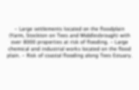
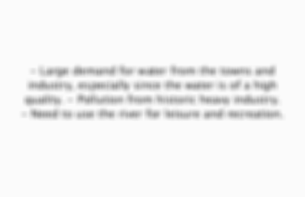
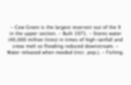
Yarm Flood Defence System
- Yarm built on meander(suffers regularly from flooding). - System cost £2.1 million. - Local people + environmental groups were consulted. - Concrete walls (enforce river banks), flood gates (allow access to river), gabions along embankment.
6 of 11
Tees Barrage
- Built 1995. - Cost £54 million. - Links north and south bank of Tees at Stockton and a system of locks allow boats+fish to go up/down stream.-Prevents flooding when high tides/storm surges.-Leisure/water sports (whitewater rafting).-Trees replanted
7 of 11
Straightening and shortening meanders at Stockton on Tees
- 19th century. - Straightening and shortening meanders moves the water away more quickly from a flood risk area, so reduces flooding. - Type of hard engineering. - Made river navigable for ships.
8 of 11
Dredging
- Scraping out mud, silt and other material, to increase width/depth(capacity of channel) so it can hold more water. - Made river more navigable for ships.
9 of 11
Warning
- Monitoring river, e.g. people upstream warning people downstream about flooding coming their way.
10 of 11
Land use zoning
- Not building expensive buildings/areas near river, as it could flood.
11 of 11

Other cards in this set

Card 2

Front

Flood causes - upper course

Back

- Upper course has impermeable rock and thin saturated peat soil. - Rainfall in upper course exceeds 2000mm each year. - River channel drops steeply from Cross Fell at 893m above sea level. - Steep V shaped valleys in upper course (relief). -

Card 3

Front

Flood risks - lower course

Back

Preview of the front of card 3

Card 4

Front

Water use

Back

Preview of the front of card 4

Card 5

Front

Cow Green reservoir

Back

Preview of the front of card 5
View more cards

Comments

No comments have yet been made

Similar Geography resources:

See all Geography resources »See all PHYSICAL LANDSCAPES OF THE UK resources »