Physical Geography Case Study
- Created by: Samclayton1818
- Created on: 01-05-17 11:23
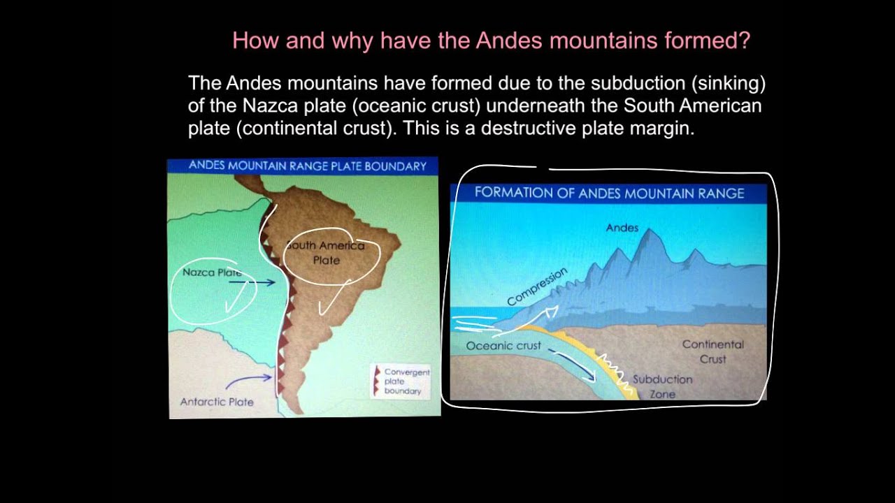
Use of Fold mountains - The Andes South America
How are they formed and which case study are we using?
- FOLD mountains form at COLLISION OR DESTRUCTIVE PLATE BOUNDARIES, where plates collide and SEDIMENT IS FORCED UPWARDS into folds to form fold montains
- FOLD mountains can form where 2 CONTINENTAL plates collide eg in the HIMALAYAS (Everset) at a COLLISION PLATE BOUNDARY.
- FOLD mountains can also form at DESTRUCTIVE plate boundaries (eg South America, Andes) where the denser oceanic plate is forced under the continental one
- CASE STUDY: The Andes, South America
What sort of things are fold mountains used for? Can you list 5 things?
1. Farming 2. Hydro-electric power 3. Mining 4. Forestry 5. Tourism
Formation of the Andes in South America
Uses of fold mountains farming & mining
Why are the Andes fold mountains difficult to live in?
- The relief is very steep making farming difficult
- the high altitude makes breathing difficult.
- The mountainous terrain make it difficult to construct roads and railways for communications
LIST TYPES OF FARMING in the Andes (think higher and lower slopes)
- most Andean farmers are subsistence farmers (food grown for themselves only)
- the highest slopes are difficult to farm so often used for grazing animals eg goats
- the lower slopes allow for small fields and crops such as SOYA, MAIZE, RICE, COTTON
- POTATOES are an important crop
- many steep slopes have ancient TERRACES , which create areas of flat land and help retain water, which is often lacking here.
- LLAMAS have been used for transporting goods and materials and for wool, meat and milk
MINING: WHY ARE FOLD MOUNTAINS GOOD AND BAD FOR MINING?
- they are a major source of metal ores (good) eg TIN, GOLD AND SILVER.
- The largest gold mine in the world is in Peru. The Spanish originally conquered South America for it's gold.
- steep slopes make access to mines difficult (steep zig zag roads are often built)
- in the Andes Llamas were used in mining in the past
YANACOCHA GOLD MINE, PERU : WORLD'S LARGEST
- DISADVANTAGES?: It is an open cast mine and the rocks containing the gold are blasted with dynamite.
- The rock is then sprayed with toxic cyanide (toxic) and then gold extracted from the solution. This can contaminate water supplies.
- The nearby town of Cajamarca has grown quickly from 30,000 when the mine started to over 240,000 people. This has put pressure on sevices like housing water and electricity and increased crime rates.
- ADVANTAGES OF THE GOLD MINE?
-
Over 50% of Peru’s exports are from mining, so the minerals are very important to the country in terms of earning money from other countries
- The mines have attracted people to the area. The town of Cajamarca has grown from 30,000 to 240,000 inhabitants. The growing town brings alternative sources of jobs…as more and more people move to the area, more jobs are created in industries other than just mining. For example…
-
o More homes are needed = builders, electricians and plumbers jobs are created.
o More shops are needed = delivery drivers, shop assistants and managerial jobs
o More leisure & entertainment facilities are demanded = jobs in restaurants, bars & cinemas etc.
Hydroelectric power and Tourism in Fold mountains
What conditions do fold mountains have that make HEP ideal?
- steep sided mountains which create high water velocitites (speed)
- narrow valleys which are more easily and cheaply damned than wider valley
- high lakes to store water
- heavy rainfall and meltwater fro snow and glaciers
- the Yuncan project is an HEP scheme in Peru
Tourism in fold mountain (Andes / Peru)
How many reasons can you give as to why tourists come to the Andes?
- NATURAL BEAUTY eg mountain scenery, volcanic peaks, glaciers and lakes
- cultural and historical sights like Machu Picchu (the lost city of the Inca's and World Heritage site.
- The Inca trail, many tourists take 3 or 4 days to walk this mountain trail, ending at Machu Picchu.I t is a world famous tourist attraction. Only 500 people are allowed to start the trek each day to protect the environment
- tourists are interested in seeing how people have adapted to living in a difficult environment
- look up coolgeography.co.uk for quiz / video on this
volcanoes how and where are they formed?
Where do we find volcanoes? Explain, which types of plate boundary? ...
- DESTRUCTIVE and CONSTRUCTIVE plate boundaries...
- & over HOTSPOTS (EG HAWAII : NOT at a boundary but rising over a very hot area of mantle)
What happens at a destructive plate boundary to form volcanoes? eg the Andes, S. America
- 1. An oceanic (denser) plate moves under a continental plate (= an oceanic trench)
- 2. When the oceanic plate reaches the mantle under the earth's crust it is destroyed (melts) due to the high pressures and temperatures, a pool of MAGMA forms.
- 3. As this magma is now less dense it rises through cracks in the crust called VENTS
- 4. It erupts on to the surface forming a volcano. (now it is called LAVA
What happens at a constructive plate boundary to form volcanoes? eg Iceland
Tectonic plates move apart from each other, eg the MID ATLANTIC RIDGE running through Iceland, where the North American Plate and the Eurasion Plate are pulling away from each other. Magma rises through the gap to form volcanoes.
volcanoes at constructive pate boundaries: Iceland
volcanoes at destructive plate boundaries (Andes)
Three different types of volcanoes...
What are three different types of volcanoes?
- COMPOSITE
- SHIELD
- DOME
What do composite volcanoes look like? Give an example...
- layers of ash and lava that have cooled and hardened
- lava is thick and flows slowly
- it hardens quickly to form STEEP SIDED volcanoes
- eg Mouunt Fuji in Japan
What do shield volcanoes look like? Give an example...
- only made of LAVA
- runny lava that flows quickly so spreads out forming a low flat volcano
- eg Mauna Loa , Hawaii
Dome volcanoes: only made of LAVA, but thick and so steep sided
types of volcanoes:Composite (both ash and lava)
types of volcano ,shield (just lava)
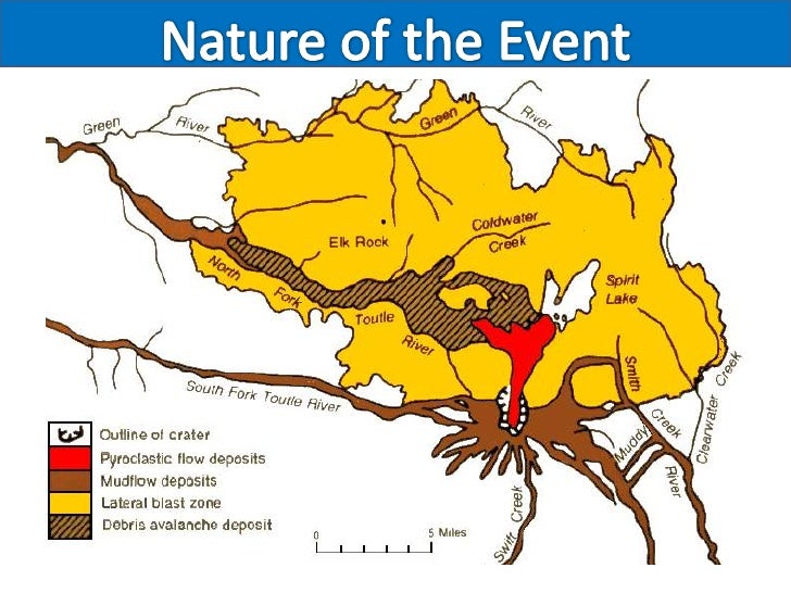
Mount St Helen's volcanic eruption 1980
Case study: Mount St Helens 1980
Where is it?
Mount St Helens is on the plate boundary between the Juan de Fuca plate and North American plate. When it erupted it permanently changed the surrounding landscape.
It is near a destructive plate margin.
What triggered the eruption?
The trigger stimulus was a magnitude 5 earthquake underneath Mount St. Helens on the 18th of May at 8:32am. This caused a bulge on the North face of the volcano to become unstable and collapse as an avalanche. The volcano then went to erupt ash and produce pyrclastic flows – currents of hot gas and ash.
Mount St Helens, primary and secondary effects
What are primary and secondary effects of an eruption?
- primary effects are the immediate effects, eg: the emission of lava, ash, rocks and gas (such as carbon di oxide and sulphur di oxide, and pyroclastic flows)
- secondary effects arethings that happen later on.
Effects of the Mount St Helen's eruption
Primary and Secondary effects
Nuée ardente (hot ash and gas) destroyed forests and logging camps.
63 people were killed, mainly by poisonous gases.
Lahars (mudflows of ash and water) covered an extensive area surrounding the volcano.
Ash blocked rivers destroying popular fishing sites and causing flooding. This in turn destroyed crops and livestock.
Flooding destroyed communications such as road and railway bridges.
Sediment carried downstream ruined barge transport on the Columbia River.
all trees within 25km of the eruption were destroyed, all fish died in local rivers and lakes, all wildlife within 25km destroyed,
mount St Helen's , map of the event
WHY LIVE NEAR VOLCANOES?
WHAT ARE THE ADVANTAGES?:
- Volcanic ash produces very fertile soil, ideal for farming e.g. Mt Etna yields 5 times the average
- Volcanoes, geysers and bubbling pools make a good tourist attraction which creates jobs and provides money for the local economy
- Steam and hot water from volcanoes can be used to produce geothermal energy without cost e.g. Japan and Iceland
- Valuable minerals and metals can be found near volcanic sites such as tin, copper, silver and gold
WHAT ARE THE DISADVANTAGES?:
- Many lives can be lost as a result of a volcanic eruption.
- If the ash and mud from a volcanic eruption mix with rain water or melting snow, fast moving mudflows are created. These flows are called lahars.
- Lava flows and lahars can destroy settlements and clear areas of woodland or agriculture.
- Human and natural landscapes can be destroyed and changed forev
HOW ARE TECTONIC HAZARDS / VOLCANOES MANAGED?
Managing hazards such as earthquakes and volcanoes can be done by: prediction and preparation.
WHAT ARE THE WARNING SIGNS?
As a volcano becomes active, it gives off a number of warning signs. These warning signs are picked up by volcanologists (experts who study volcanoes) and the volcano is monitored.
Hundreds of small earthquakes are caused as magma rises up through cracks in the Earth's crust.
Temperatures around the volcano rise as activity increases.
When a volcano is close to erupting it starts to release gases. The higher the sulfur content of these gases, the closer the volcano is to erupting.
WHAT ARE THE MONITORING TECHNIQUES FOR VOLCANOES?
HOW ARE VOLCANOES MONITORED?
Seismometers are used to detect earthquakes.
Thermal imaging techniques and satellite cameras can be used to detect heat around a volcano.
Gas samples may be taken and chemical sensors used to measure sulfur levels.
The techniques available for predicting and monitoring volcanic activity are becoming increasingly accurate. Volcanoes such as Mount St Helens in the USA and Mount Etna in Italy are closely monitored at all times. This is because they have been active in recent years and people who live nearby would benefit from early-warning signs of an eruption. However, as well as prediction, people need to be prepared for an eruption.
HOW CAN WE PREPARE FOR ERUPTIONS (MEDC / LEDC)
Preparing for volcanic eruptions
A detailed plan is needed for dealing with a possible eruption. Everyone who could be affected needs to know the plan and what they should do if it needs to be put into action. Planning for a volcanic eruption includes:
- creating an exclusion zone around the volcano
- being ready and able to evacuate residents
- having an emergency supply of basic provisions, such as food
- funds need to be available to deal with the emergency and a good communication systemneeds to be in place
- OBVIOUSLY MEDCS HAVE MORE RESOURCES TO DO THIS EFFECTIVELY
What are earhtquakes and how are they measured?
- Earthquakes are caused by the release of built-up pressure inside the Earth's crust. An earthquake's power is measured on the Richter scaleusing an instrument called a 'seismometer'.
-
An earthquake is the shaking and vibration of the Earth's crust due to movement of the Earth's plates (plate tectonics).
Earthquakes occur when tension is released from inside the crust. Plates do not always move smoothly alongside each other and sometimes get stuck. When this happens pressure builds up. When this pressure is eventually released, an earthquake tends to occur.
- The point inside the crust where the pressure is released is called the focus. The point on the Earth's surface above the focus is called the epicentre.
Earthquake energy is released in seismic waves. These waves spread out from the focus. The waves are felt most strongly at the epicentre, becoming less strong as they travel further away. The most severe damage caused by an earthquake will happen close to the epicentre.
Earthtquakes: causes / plate tectonics diagram
Haiti Earthquake LEDC, 2010
What is the Location?
Haiti is a small island located in the Caribbean, South East of the USA and East of Cuba. Its capital city is Port-au-Prince.
What were the causes?
Causes
The earthquake was caused by the North American Plate sliding past the Caribbean Plate at a conservative plate margin. Both plates move in the same direction, but one moves faster than the other.
The pressure that was built up because of the friction between the 2 plates was eventually released causing a magnitude 7 earthquake on the Richter Scale with an epicentre 16 miles West of Port-au-Prince and a shallow focus of 5 miles.
The earthquake struck at 16:53 (4:53pm) local time on Tuesday 12 January 2010.
Remember how poor Haiti is
People living in poverty here, 80% of people live on $2 or less per day
primary effects of the Haiti earthquake
what were the Primary effects? (caused directly by the earthquake)
316,000 people were killed and 1 million people were made homeless. 3 million people were affected by the earthquake
250,000 homes and 30,000 other buildings, including the President’s Palace and 60% of government buildings, were either destroyed or badly damaged
Transport and communication links were also badly damaged by the earthquake
Hospitals (50+) and schools (1,300+) were badly damaged, as was the airport’s control tower
The main prison was destroyed and 4,000 inmates escaped
secondary effects of the Haiti Earthquake
what were the Secondary effects? (result from primary effects)
1 in 5 people lost their jobs because so many buildings were destroyed. Haiti’s largest industry, clothing was one of the worst affected
The large number of deaths meant that hospitals and morgues became full and bodies then had to be piled up on the streets
he large number of bodies meant that diseases, especially cholera, became a serious problem
t was difficult getting aid into the area because of issues at the airport and generally poor management of the situation
People were squashed into shanty towns or onto the streets because their homes had been destroyed leading to poor sanitation and health, and looting became a real problem
Cholera was a major problem following the earhtquake
Responses during the Haiti earthquake: short term
Waht were the Short Term responses?
$100 million in aid given by the USA and $330 million by the European Union
810,000 people placed in aid camps
115,000 tents and 1,000,000+ tarpaulin shelters provided
Healthcare supplies provided to limit disease
Lack of immediate aid through poor planning, management and access meant that people had to try and rescue each other
4.3 million people provided with food rations in the weeks following the earthquake
Haiti Earthquake 2010, LEDC responses long term
what were the Long Term responses?
98% of the rubble on the roads hadn’t been cleared restricting aid access
1 million people still without houses after 1 year so still have to live in aid camps
Support for people without jobs, which equates to nearly 70% of the population, through cash/food-for-work projects
Temporary schools created and new teachers trainee
Water and sanitation eventually supplied for 1.7 million people
diagram of Haiti (conservative plate boundary)
What are the benefits of volcanic regions: summary
Tourism?: volcanic landscapes can have beautiful scenery that attracts visitors. Means lots of businesses set up, e.g. to sell souvenirs, hotels, restaurants, tour guides, transport. Hot springs and mudbaths have health benefits. E.g. Yellowstone National Park.
Agriculture?: Lava breaks down into fertile soil, especially in wet and hot locations (topical locations), e.g. Hawaii which produces sugar and coffee from volcanic soils.
Minerals?: Copper, gold, silver, diamonds and tin form in rich ‘veins’ in the rock where lava has cooled down. Also, raw materials for many building materials and chemicals used in industry come from volcano
Geothermal Power?: Steam from water heated by hot rocks below the surface drives turbines to make electricity. Widely used in New Zealand, Iceland (70% of energy needs) and Hawaii. Renewable, clean form of energy. Geysers in northern California is biggest geothermal development in world.
What are the short term effects of earthquakes?
SHORT TERM effects earthquakes: social
- People may be killed or injured. Homes may be destroyed. Transport and communication links may be disrupted. Water pipes may burst and water supplies may be contaminated.
Economic:
- Shops and business may be destroyed. Looting may take place. The damage to transport and communication links can make trade difficult.
Environmental impact
- The built landscape may be destroyed. Fires can spread due to gas pipe explosions. Fires can damage areas of woodland. Landslides may occur. Tsunamismay cause flooding in coastal areas.
What are the long term effects of earthquakes?
LIst the long term impacts of earhtquakes
- Disease may spread. People may have to be re-housed, sometimes in refugee camps.
- The cost of rebuilding a settlement is high. Investment in the area may be focused only on repairing the damage caused by the earthquake. Income could be lost.
- Important natural and human landmarks may be lost.
Which factors affect how severe earthquake damage
What affects how severe the damage is from an earhtquake... list the factors
Factors affecting the impact of an earthquake
- Distance from the epicentre - the effects of an earthquake are more severe at its centre.
- The higher on the Richter scale, the more severe the earthquake is.
- Level of development (MEDC or LEDC) - MEDCs are more likely to have the resources and technology for monitoring, prediction and response.
- Population density (rural or urban area). The more densely populated an area, the more likely there are to be deaths and casualties.
- Communication - accessibility for rescue teams.
- Time of day influences whether people are in their homes, at work or travelling. A severe earthquake at rush hour in a densely populated urban area could have devastating effects.
- The time of year and climate will influence survival rates and the rate at which disease can spread.
compare the effects of earthquakes in LEDC & MEDC
Earthquakes and volcanoes in LEDCs
LEDCs often suffer more from the effects of volcanoes and earthquakes than MEDCs.
List The effects of an earthquake or a volcano in LEDCs...
- Communication systems may be underdeveloped, so the population may not be well educated about what to do in the event of a volcanic eruption or an earthquake.
- Construction standards tend to be poor in LEDCs. Homes and other buildings may suffer serious damage when a disaster occurs.
- Buildings collapsing can cause high death tolls.
- Evacuation and other emergency plans can be difficult to put into action due to limited funds and resources.
- Clearing up can be difficult. There may not be enough money to rebuild homes quickly and safely. Many people could be forced to live in emergency housing or refugee camps.
Christchurch Earhtquake, New Zealand, 2011 (MEDC)
Where is the Location?
New Zealand is located in the Pacific Ocean in the continent of Oceania. It is South East of Australia and consists of a North and South Island. Its capital city is Wellington.
What were the details / causes?
The 6.3 magnitude earthquake struck New Zealand at 12:51 on 22 February 2011. The epicentre was 6 miles South East of Christchurch and the focus was very shallow at 3.1 miles.
Which type of plate boundary was involved?
The earthquake occurred on a conservative plate margin where the Pacific Plate slid past the Australian Plate in the opposite direction. It was technically an aftershock from a larger earthquake in 2010 but the impacts were more severe.
Christchurch, New Zealand Earthquake 2011, diagram
PRIMARY IMPACTS OF THE CHRISTCHURCH EARTHQUAKE (NZ
What were the primary effects? (caused directly by the earthquake)
- 181 people were killed and around 2,000 people were injured
- Hundreds of kilometres of water and sewage pipes were damaged
- 50% + of Central City buildings severely damaged including the city’s cathedral which lost its spire
- Liquefaction (where the ground gets saturated and loses strength) caused lots of damage to roads and buildings
- Part (size of 20 football fields) of the country’s longest glacier was broken off creating a large iceberg
- 80% of the city was without electricity
Secondary impact Christchurch 2011
What were the secondary impacts of the earthquake?
- Business were put out of action for long periods causing losses of income and jobs
- Schools had to share classrooms because of the damage to other school buildings
- Damage to roads through liquefaction made it difficult for people and emergency services to move around
- People were affected mentally by the earthquakes and needed support
- Christchurch could no longer host Rugby World Cup matches so lost the benefits, e.g. tourism and income, they would bring
Christchurch Earthquake , MEDC responses
How wealthy is Christchurch compared to Haiti?
GDP average income per person per year is $27 700 per person per year
What were the Responses: short term?
- Cared for the most vulnerable people and ensured people were safe from dangerous buildings
- Chemical toilets were provided for 30,000 residents
- Areas were zoned (green, orange, white, red) to classify damage/cost of repairs
- nternational aid was provided in the form of money (around $6-7 million) and aid workers
What were the Responses: long term?
- Paid $898 million in building claims
- Provided temporary housing and ensured all damaged housing was kept water tight
- Water and sewerage was restored for all residents by August (quake was in February)
- Roads and houses were cleared of silt from liquefaction by August and 80% of roads/50% of footpaths were repaired
Christchurch Earthquake 2011, why worse than 2010
Weaker with a worse impact? WHY WAS THIS?
The February 2011 earthquake was smaller in magnitude than the 2010 quake, but the earthquake was more damaging and deadly. The reasons for this are;
1. Epicentre was closer to Christchurch
2. The Focus was shallower, only 5 kilometres underground, whereas the September quake was 10 kilometres deep.
3. The February earthquake occurred during lunchtime on a weekday when the CBD was busy, and many buildings were already weakened from the previous quakes. People died in collapsing city centre buildings. The 2010 earthquake happened at night and caused less building damage.
4. The Peak Ground Acceleration (how much the ground shakes) was extremely high and made it "almost impossible" for buildings to survive intact.
5. Liquefaction was significantly greater than that of the 2010 quake, causing the upwelling of more than 200,000 tonnes of silt. This undermined many foundations and destroyed infrastructure, damage which "may be the greatest ever recorded anywhere in a modern city".
Indian Ocean Tsunami, Boxing Day 2004
What caused the Boxing Day Tsunami, 2004
On 26 December 2004 a tsunami occurred in the Indian Ocean. It was the result of the Indio-Australian Plate subducting below the Eurasian Plate. It was caused by an earthquake measuring more than magnitude 9. The earthquake caused the seafloor to uplift, displacing the seawater above.
- In open ocean the tsunami measured less than 1 metre high.
- The tsunami travelled at speeds up to 800km per hour.
- When the Tsunami reached the shores, the height of the wave increased to 15 metres in some areas.
map of the Indian Ocean Boxing Day TSunami, 2004
Impacts of the Indian Ocean Tsunami
What were the Main impacts????
- A quarter of a million people died.
- Two million people were made homeless.
- People were swept away in the waters, which arrived rapidly and with little warning.
- Thirteen countries were affected, the worst being Indonesia.
- Indonesia was hit by the tsunami first. Fourty-five minutes later the tsunami reached Thailand.
- Mangrove swamps helped to act as a barrier to reduce the energy of the water in some areas.
- Short-term aid, such as water purification tablets, temporary housing and medical supplies were given from international countries.
- Islands reliant on tourism and fishing, such as the Maldives, had to rebuild their industries.
- An early warning system between countries surrounding the Indian Ocean has been set up.
Indian Ocean Tsunami, 2004 Death Toll and Aid Orga
immediate responses to the Tsunami 2004
What were the Responses to the tsunami?
Non-Governmental Organisations (NGOs) and local authorities typically have immediate and secondary responses to devastation of this kind.
Immediate responses
-
Search and rescue.
-
Emergency food and water.
-
Medical care.
-
Temporary shelter.
-
Re-establishing infrastructure and communications.
secondary responses to the Indian Ocean Tsunami
What were the Secondary responses?
-
Re-building and improving infrastructure and housing.
-
Providing jobs and supporting small businesses.
-
Giving advice and technical assistance.
Responses to the 2004 Indian Ocean tsunami can also be divided into short and long term:
short term responses to the Tsunami
What were the Short-term responses?
-
In many areas local communities were cut off and had to help themselves.
-
The authorities ordered quick burial or burning of the dead to avoid the spread of disease.
-
Food aid was provided to millions of people, eg from the World Food Programme.
-
$7 billion (just under £4.5billion) of aid was promised by foreign governments – but there were complaints that not all money pledged was given.
-
The British public gave £330 million through charities, eg the average Actionaid donation was £84 – their best ever response.
Indian Ocean Tsunami, Long term responses
What were the long-term responses?
-
Reconstruction is still taking place.
-
International scale: an Indian Ocean tsunami warning system has now been set up.
-
Local scale: some small-scale sustainable development projects have been set up by charities to aid recovery and help local people help themselves to rebuild and set up small businesses.
What causes Tsunamis?
A tsunami is a huge wave, usually caused by volcanic or earthquake activity under the ocean, which can eventually crash onto the shoreline. The effects on a community can be devastating.
What causes a tsunami?
When an earthquake, volcano or landslide happens on the ocean floor, water is displaced. This water forms the start of the tsunami.
When the waves reach shallower water:
- their height can increase by several metres
- the shallow water slows the wave
- the waves get closer together
It is hard to see that a tsunami is approaching. The most obvious sign is the coastal water retreats just before the waves reach the shore. This is actually the trough of the wave following behind.
Related discussions on The Student Room
- should i take alevel ECCONOMICS or GEOGRAPHY? »
- A Level Geography Edexcel 18/20/24 markers »
- Personal Statement »
- A-level Geography Study Group 2022-2023 »
- should i do geography a level? »
- Geograpy BSc »
- really stressed for Geography »
- A-level Geography Study Group 2023-2024 »
- GCSE Geography Study Group 2023-2024 »
- Geography or Chemistry A level for a physics(??) degree? »
Comments
No comments have yet been made