Geography - Coasts
- Created by: ZodiacRat
- Created on: 04-06-15 08:50
Coastal System
- The coastal zone is the area in which terrestrial environments influence marine environments and vice-versa. It is the interface between land and sea.
- 50% of the human population lives on coastal plains and in other locations within easy access to the sea, so coastal zones are vitally important.
- The coast as a system has inputs, processes, outputs and is constantly changing.
- Coasts are in dynamic equilibrium.
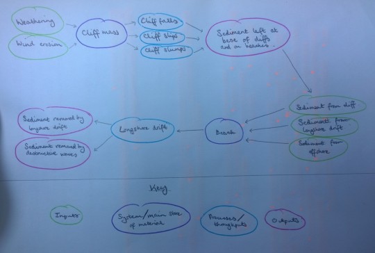
- Within the coastal system there are two smaller systems: the cliff system and the beach system.
- Cliff system: inputs of weathering, wind erosion, thoughputs of cliff mass movement, output of sediment at the base of the cliff, either deposited or transported by marine processes.
- Beach system: inputs of sediment form longshore drift, cliffs and offshore, throughputs of longshore drift, output of longshore drift, and destructive waves carrying sediment offshore.
- Littoral/sediment cells can be regarded as closed systems from which nothing is gained or lost. It is easy for fine sediments to find their way around headlands into neighbouring cells. Sedminent cells can vary in size, larger ones are divided into small sections (sub-cells), e.g. Great Orme.
Waves
- Slight increases in wave height can generate large increases in energy. Average wave pressure can be three times greater during a storm.
- Wave power is a potential source of renewable energy.
- As waves approach shallow water, friction with the sea bed increases. The point at which the wave breaks is known as the plunge line. The body of water which then rushes up the beach is called the swash, while any water returning down to the sea is the backwash.
- Constructive waves are those which have a swash stronger than a backwash, meaning they deposit material on beaches and are generally shallower in size with less distance between the crest and trough.
- Destructive waves are those which have a backwash stronger than a swash, meaning they erode material from beachers and cliffs and are generally taller in size with a larger difference between the crest and trough.
Coastal System: Diagram
KQ 2: Weathering/erosion
- Weathering is the disintegration and decomposition of rock in situ. It is the natural breakdown of rock and involves the movement of material. It is the first stage of the wearing down of the landscape. It loosens material which can then be transported by agents of erosion.
- The degree of weathering depends upon the structure and mineral composition of the rocks, lcoal climate, vegetation and length of time durig which weathering process operate.
- Mechanical/physical weathering: Disintegration of rock into smaller particles by mechanical processes without any change in chemical composition. More likely to occur inn areas devoid of vegetation (deserts, high mountains, artic regions). Usually produces sands.
- Chemical weathering: Decomposition resulting from a chemical change. Produces changed substances ad solubles, usully forms clay. More likely to take place in warmer, moist climates where there is associated vegetation cover.
- Salt crystallisation: Causes the decomposition of rock by solutions of salt.
- Pressure release: Process whereby overlying rocks are removed by erosion. Causes underlying rocks to expand and fracture parallel to the surface.
- Oxidation: Occurs when iron compounds react with oxygen to produce a reddish-brown coating. Dissolved oxygen in the soil or the atmosphere affects iron minerals.
- Hydration: Process whereby certain minerals absorb water, expand and change.
KQ 2: Types of weathering/erosion
- Corrosion: chemical weathering by the dissolving of rock and sediment in saline water.
- Water-layer weathering: Tidal movements allow alternate wetting and drying of rock exposed. Effect of chemical weathering processes of rock minerals combime to weather the rocks. Layer is removed by erosional processes, fresh surface is exposed, so rock face retreats progressively.
- Marine erosion: Direct erosion by the sea occurs in restricted zones between wave splash and wave base. Shore area affected will vary according to fluctuations in tidal range. Three main erosional processes.
- Quarrying/hydrostatic pressure: The force of a breaking wave exerts considerable hydrostatic pressure within joint systems by air compression as waves break on rocks, followed by rapid air expansion as waves subside, can pull away blocks of rock from a cliff face or remove smaller weathered fragments. Can also hammer a rock surface. Captivatoin effects can occur where bubbles form in the water, which erode by hammer-like pressure effects as they erode.
- Abrasion/corrasion: Breaking waves with sand and shingle causes ballistic impact. The size and amount of sediment available to be used as abrasives and the type of wave will determine the effectiveness of this process.
- Attrition: Gradual wearing down of rock particles by impacts and abrasion during transport. Reduces the size and causes rounding of sediment particles as they're moved by waves, tides and currents.
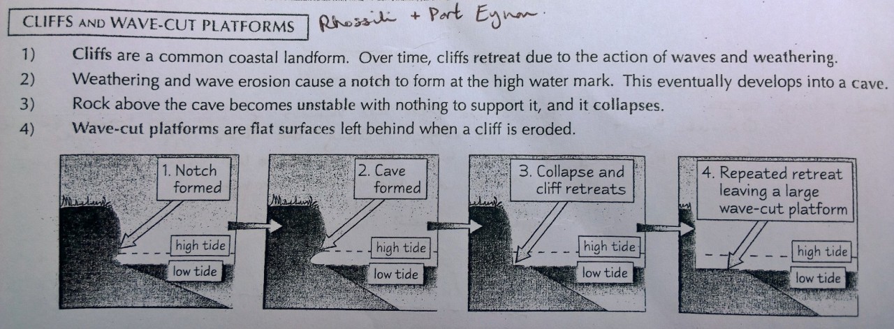
KQ 2: Cliffs and wave-cut platforms
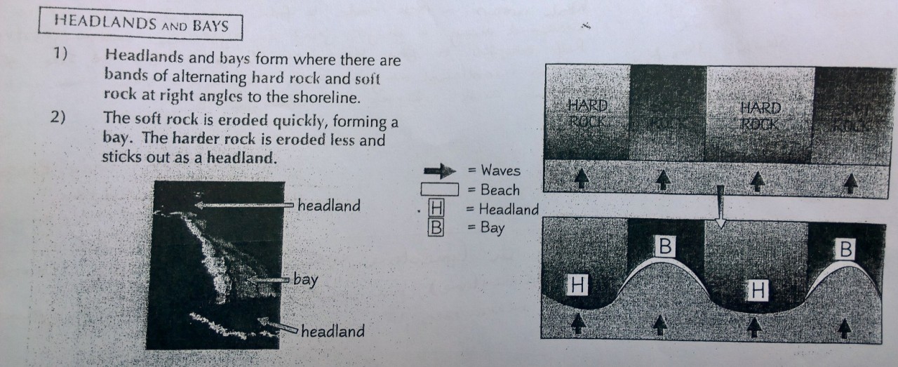
KQ 2: Headlands and bays
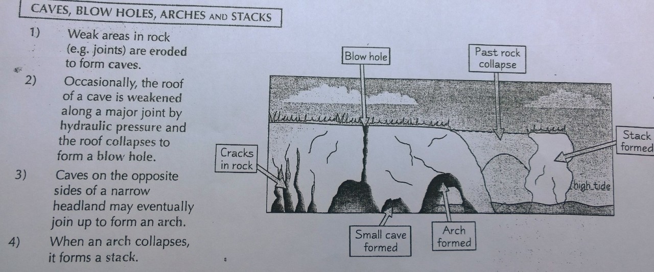
KQ 2: Caves, blow holes, arches and stacks
KQ 3: Depositon
- Transportation of sediment occurs via the process of longshore drift.
- Wave transport: Waves transport material in the same way rivers transport material.
- Traction: Largest rocks are rolled along the sea bed.
- Saltation: Sand and pebbles bounce along the sea bed.
- Suspension: Silt and clay are supported within the water column.
- Solution: Minerals dissolved in water are carried in the flow.
- Load is the total amount of material carried by a wave.
- Waves needs energy to carry material, and need more energy to carry larger particles like rocks and boulders, weakest waves only transport sand and clay. Deposition occurs when waves lose energy.
- Direction of sediment movement is affected by currents and can be transported longshore or onshore (parallel to the coast or up and down the beach).
- Longshore drift: Swash moves diagonally up the beach at the same angle as the wave.
- Sediment can be deposited by waves, mass movement, rivers entering the sea, or human activity.
- Where sand/shingle is deposited rather than removed, inputs are greater than outputs.
- Deposition takes place along stretches of the coastline where waves are not powerful, where the rate of deposition exceeds the rate of erosion, and indented coastline and river estuaries.
KQ 3: Spits
Long, narrow accumulations of sand/shingle with one end jointed to the mainland and the other projecting out to sea or extending part way across a river estuary.
The composition of the spit depends on the availability of sediment and wave energy.
Composite spits occur when larger-sized shingle is deposited before finer sands.
Spits occur as a result of longshore drift. For example, if prevailing winds and maximum fetch are from the south-west, the material would be carried eastwards.
Some spits develop a hooked end, which may be due to changing prevailing winds or wave refraction at the end of the spit.
In some places there are double spits, which occur when there are two opposing swells and therefore two spits developing in converging directions.
Spits may join up to other spits or another body of land to form a barrier beach.
Example: Studland Bay and Poole Harbour, Dorset.
Tombolos
- Features that devleop when longshore drift joins an island onto either the mainland or a larger island.
- Example: Chesil Beach shingle ar has grown to join the former Isle of Purbek onto the mainland and has cut off a larger area of sea to form Fleet Lagoon, Britain's largest tombolo.
- Wave refraction around the island results in a wave-energy shadow where increased deposition occurs building up the tombolo.
KQ 3: Barrier bars and beaches
A barrier beach is where abeach extends across an indentation of the coastline to join two headlands.
Example: Start Bay, Devon.
If the beach is separated from the mainland, the feature is called a barrier islands.
Example: Scolt Head Island, Norflok.
Barrier islands are common in low tidal ranges, doinated by swell waves where the offshore coastline is gently sloping over wide continental shelves.
Some islands can be made through spits being broken through by storm waves and become detached from the mainland.
KQ 3: Cuspate forelands
Low-lying headands that result from the development of a large area of sediments taking on a cusped profile.
Cuspate forelands can develop from two opposing directions of swell and the consequent longshore drift, or the shape can be derived from the work of two converging rip currents.
Example: Dungeness in Kent.
KQ 3: Estuaries
An estuary is the last section of section of a river before it flows out into the sea, where there are tidal influences and therefore daily fluctuations in the water levels.
They are zones where marine processes determine the formation of an estuary.
At high tide the sea collides with the river and loses energy. This leads to deposition from the sea and river, creating mudflats.
Example: Loughour estuary Loughor estuary was created by a rise in sea levels. Now when the river meets the sea, deposition occurs and creates mudflats. These are exposed at low tide. 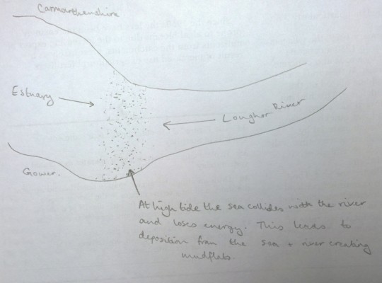
KQ 4: Geology
Different rocks erode at different rates depending on their resistance rates.
Igneous rocks such as granite erode more slowly and produce steep-sided cliffs, e.g. Land's End.
cliffs composed of unconsolidated sands and clays, .e.g. Barton-on Sea, sufer mass-movement processes os slides, slumps and flows.
Granite (Cornwall, Land's End - 1mm/year), llimestone (Gower coastline - 1mm-1cm/year), shale (1cm/year), chalk (Old Harry - 1cm-1m/year), glacial drift deposits (1-10m/year), volcanic ash (>10m/year), old red sandstone (Cefyn Bryn).
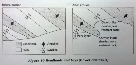
The differing strengths of rock composition can result in differential erosion. Resistant rock outcrops will form areas of higher relief with cliffs and headlands, and outcrops of weaker rocks will form lowland areas with bays and inlets.
KQ 4: Rock orientation
The orientation of the coastlinewith the local geology also affects the shape o the coastline.
Discordant coastlines are where the general trends of mountains and hills are at right angles to the shore. They create alternate bays and headlands.
Example: South coast of Gower and Isle of Purbeck, Dorset.
Concordant coastlines have a geological trend that is parallel to the shoreline. This creates coastlines which are dominated either by relatively straight, rocky coastlines or have a series of long narrow islands parallel to the shore.
Example: Rhossili headland to Port Eynon, and Istrian Peninsulla in Croatia through to Island of Corfu in Greece.
KQ 4: Lithological structure
Differential erosion can occur at a small scale when areas of structural weakness are present. Along a cliff face, joints, bedding planes and fault lines are eroded more quickly (especially due to hydraulic pressure). This will erode the cracks until sea caves develop.Example: Leather's Hole, Three Cliffs.
Caves can erode all the way through the cliff to form an arch. Example: Devil's Bridge on Worms Head, Rhossili.
A blowhole can form in the roof of an arch if a vertical line of weakness is present. Example: Devil's Bridge.
Oher joints and fault lines can be eroded back into the cliff to form geos such as Priest's Nose or Huntsmans Leap, Pemrokeshire.
Cliff profiles reflect the influence rock lithology and structure, sub-aerial processes, relief, wave energy, human activities and past processes.
Uniform horizontal strata produce steep cliffs as layers break off in large blocks.
Steep seaward dips are created as the rock slabs slide down the cliff along bedding planes. Example: Pennard Cliffs, Gower.
KQ 5: Management of coastal environments
Processes of weathering and mass movement along the coast can endanger buildings as with Holbeck Hall Hotel in North Yorkshire in 1993.
- Was built of top of the cliffs behind South Bay in Scarborough. Cliffs consisted largely of clay but hotel wasn't considered in danger as it was 60-70m away from the edge.
- Early summer of 1993 - period of dry weather cracked much of the clay. Followed by heavy rainfall, penetrated cracks and began to cause slippage of clay layers.
- Had to be demolished by contractors.
Happisburgh, Norfolk - damaged revetement.
- Government policy has changed in recent years it is no longer cost effective to aim to preserve the coast.
- Communities have often grown up knowing they are safely protected, which has encouraged further growth.
- Some areas have been chosen for schemes involving managed retreat.
- 26 properties have been lost in the last 15 years.
- The impacts extend 2 miles inland.
- People have had quotes on how much their property in Happisburgh is worth as low as £1.
- Homeowners are offered no compensation for their homes.
KQ 5: Management of coastal environments
Transport and deposition of material can silt up estuaries and make harbour entrances more difficult to navigate, e.g. Poole Harbour in Dorset.
Coastal landforms can also attract toursists, e.g. Gower Penninsula.
Coastal lowlands are important for food production, e.g. Pembrokeshire.
Coastal ports play a leading role in world trade, e.g. Milford Haven or Bristol Docks.
Future sea level rises may lead to more erosion and this will lead to faster coastal collapse in certain areas.
KQ 5: Impact of human activities
- Important large-scale industries that require a lot fo space often have coastal locations due to the supply of flat land and access to the coast for transport, e.g. Steelworks at Port Talbot and oil refineries in Milford Haven.
- Tourism impacts processes in cases where local authorities install seawalls, promenades and groynes to build sandy tourist beaches, e.g. Bournemouth - lots of groynes to maintain sand.
- Holbeck Hall Hotel could have played an instrumental role in its own collapse because the extra weight of the structure could have made the underlaying clay more susceptible to slumping.
- Impacts of leisure and recreation activities such as footpath erosion, people trampling on areas with fragile coastal ecosystems such as sand dunes, e.g. Oxwich Bay and Port Eynon sand dunes are being eroded when people walk across them, causes vegetation to die away and no longer holds the sand dune together, then eroded by the wind in a 'blow out'.
- Seawalls, jetties and docks will alter local tidal currents and influence local erosion and deposition patterns. offshore dredging can be done to benefit humans. May be used for the building industry or to reduce the build-up of sand in ports.
- Poole Harbour Commissioners (PHC) organised a Channel Deepening Project to dredge material to ensure the channel remains deep and wide enough for ferries and ships.
- 2,00,000m cubed of sand and silt were dredged and used by the Coast Protection Authorities for beach replenishment to protect Poole Bay. This provided significant cost saving and reduced the overall environmental effect by minimising dredging and sea disposal.
KQ 6: Coastal protection - hard engineering
Hard engineering: the use of structures which aim to resist the energy of waves and tides.
Sea walls: Aim to prevent erosion by providing a barrier which reflects water energy. Older sea walls are vertical in design, reflected energy is able to pick up sediment from the beach in front of the sea wall, caled beach scouring and can potentially undermine the wall. Very expensive structures, from £2000/m for a simple structure, up to £5000/m for a two-level wall with a promenade. 90% of sea walls require expensive maintenance within 10 years of being built, 96% suffer damage over a 30-year period. Effective, but has downsides - accelerated erosion levels as waves differentially erode protected and unprotected sections, scouring behind the wall may cause collapse, falling beach levels due to scouring, toe of the sea wall is determined as beach levels fall, water pressure can build up behind walls and cause collapse. e.g. Eastbourne, Sussex.
Revetements: Cheaper alternative to sea walls, consist of timber, steel or concrete posts driven into the beach with connecting timber or a rock boulder infill. Aim to dissipate energy rather than reflect it. Waves pass through the structure but less energy at cliff foot. Permeable, allow sediment to pass through them, further protection. However, beach scouring can occur. Relatively cheap £1200/m, but relatively short life since timbers can be quickly damaged and can be quickl undermined by scouring. e.g. Barton on Sea.
KQ 6: Coastal protection - hard engineering
Groynes: common along UK coastline, increases the natural rate of sedimentation and build up a protective beach at the cliff foot. Also used to retain a beach on sedimentary coastlines such as spits, protection from coastal flooding, or recreational purposes. Made oft imber, steel or concrete, built perpendicular to the shoreline to reduce sediment movement by longshroe rist. Interrupt and reduce longshore currents, reorientates the wave front with deposition, and recuces the angle of wave approach and therefore current velocityy. Further deposition and formation of groyne bays. Characteristics of groynes are important, e.g. Heacham North beach groynes are being shortened because they're diverting material drifting southwards into the offshore zone. Can be 100% efficient in stopping longshore drift. Possibly increase rates of erosion elsewhere.
Beach pumping: increase the natural rates of sedmientation. Shingle beaches are highly permeable, so energy wave backwash is low as the water soaks innto the beach. Deposition of sand into offshore zone as not as permeable. Plastic drainage pipes installed 2-3m below surface reduces backwash energy, backwash scour and sediment build-up is increased.
KQ 6: Coastal protection - soft engineering
Soft engineering: Aim to work with rather than against natural processes and provide a more environmentally friendly approach to the management of erosion and flooding. Do not stop coastal erosion completely but work with it to achieve dynamic equilibrium so eroson is reduced.
Beach filling and nourishment (Swanage): Import of foreign or borrowed material. Beach filling is the dumping of a large amount of material. Beach nourishment is the gradual feeding of beach material over a period of time. Do not involve costly engineering structures. Compatibilit of imported material with natural sediment is important; if too small it will be quickly remove by wave action, if too course, supratidal ecosystems may be changed and sand-dune formation reduced. Both can dissipate more wave energy that that which already exists, applies where natural beach sediment has been depleted by artificial causes. Major problem is that most sediment comes from relatively cheap offshore dredging, which can leave holes in the sea bed and can affect wave refraction and patterns, and may impede nearshore-offshore sediment exchanges. Land-based sources pose problems of cost and environmental problems with quarrying.
KQ 6: Coastal protection
Technical feasability: The primary concern of coastal engineers. Not all schemes will be appropriate to an area, depends on the complex natural processes operating locally. Need a detailed knowledge of coastal processes and continued monitoring. Geology is also important, e.g. Barton on Sea, sea wall not technically feasible due to the nature of the Barton Clay and lack os sustainability to form foundations of a wall.
Economic viability: Cost-benefit analysis (CBA) widely used technique to analyse a project. Ensure that finite financial resources are allocated for the maximum benefit of people. Need to balance the costs of a scheme, e.g. costs of building and maintaining hard-engineering structures, over their expected useful life. Need to consider value of building and infrastructure which would be protected from erosion if project takes place. Cost-benefit ratio must be 1:1 to be economically viable. Maritime councils are unlikely to receive grant aid from governments with a negative cost-benefit ratio. Project is more likely to be approved when benefit exceeds the cost.
Environmental concerns: Considerations in deciding on the type of scheme/whether a scheme should take place at all. Must consider how sediment changes may be affected over a large area within a coastal sediment cell or offshore. Impacts can be very sever, may result in the need for even more protection measures.
KQ 6: Coastal protection - rising sea levels
Eustatic rise is approximately 1mm/year, natural processes can maintain an equilibrium by moving sand and shingle to maintain the most energy-efficient beach profile or by adjusting cliff-recession rates so that shoreline platforms remain at a relatively constant level wave height. Sudden rises of sea level as a result of human-induced global warming means natural processes will not have time to make adjustment to new conditions. Deeper water at the foot of cliffs result in greater wav energy to increase cliff-foot erosion. Material desposited by mass-movement processes will be more quickly removed, shorter period of toe protection, increase in the rate of the cliff erosion cycle.
KQ 6: Coastal protection - soft engineering
- Swanage - Beach replenishment: Sand dredged from Poole Harbour (October 2005 - June 2006), £5 million cost, Swanage received 90,000m cubed of material. Protects the area-landscape behind the beach, uses natural materials without trying to alter processes.
- Medmerry - Managed retreat: £28m cost of managed realignment, 7km of new sea wals up to 2km. 350 homes, 2 holiday parts and water treament works better protected. 2 car park, 4 viewpoints and 10km of cycle paths and bridleways constructed. Protected wildlife reserve by RSPB, protected until one-in-one-hthousand-year flood.
- Pevensey - beach noursihment/filling: Allowed 150 groynes to erode so four construction companies could go into partnership with Environment Agency to create Pevensey Bay Consortium, groynes not replaced, instead soft engineering was used to build up the coastline again.
- Pevensery Castle was at risk of being closer to shore, sea level rise and storm surges increasing,coast receeding back to its original position, vilage and farms at risk due to erosion, shingle transported every high tide by waves, seaside resorts to the west deliberately retaining material which would have been naturally deposited in Pevensey.
- Locals now secure in their homes, properties and livelihoods until 2025, saved project costs by only using soft engineering, 2000 tonnes of shingle gathered at high tide, 25 years to decide best method of protection, but till on a time limit. Recycles waste product by placing tyes where dredging took place, then covered with shingle. Methods have become a tourist attraction, more beach built up gives more new habitat, saves on environmental pollution and disruption.
KQ 6: Coastal protection - hard engineering
Brighton - groynes: Beach nourishment to maintiain bay, wall of flint built at base of cliffs to limit erosion and undercutting in 1975, hard engineering projects by Brighton English Channel coast authority, groynes protecting from longshore drift.
Problems: Chalk cliffs - erode quickly, rising sea levels, highly variable tides, coastline eroding too quickly so must resort to expensive hard engineering, longshore drift swiftly removing material from the beach, tourist attractions and hotels right on the coast that is vulnerable and needs protecting.
Result: Large sea wall to protect settlements, still well-populatied with recreational popularity, expensive funding required, hotels protected by sea wall but expensive to maintain, shingle must be replaced - costly, groynes must be maintain - costly.
Related discussions on The Student Room
- Geography NEA help »
- Geography Nea AQA Help »
- Didn't put a cross in the box - Edexcel A level Geography »
- AQA A-Level Geography Coursework »
- geography a level nea »
- Cie Geography A level oct/nov 2023 series »
- Geography A-Level »
- OCR a level geography nea »
- What's better to pick at gcse geography or history »
- Geography Edexcel b »
Comments
No comments have yet been made